Jaipur geodata
Jaipur (Rajasthan) is a seat of a first-order administrative division; located in India in Asia/Kolkata (GMT+5.5) time zone. With population of 2,711,758 people, there are 10 cities with bigger population in this country. Compared to other cities in India, 77.9% of cities are located further ↓South; 75.8% of cities are located further →East and 78.3% of cities have lower elevation than Jaipur. Note1


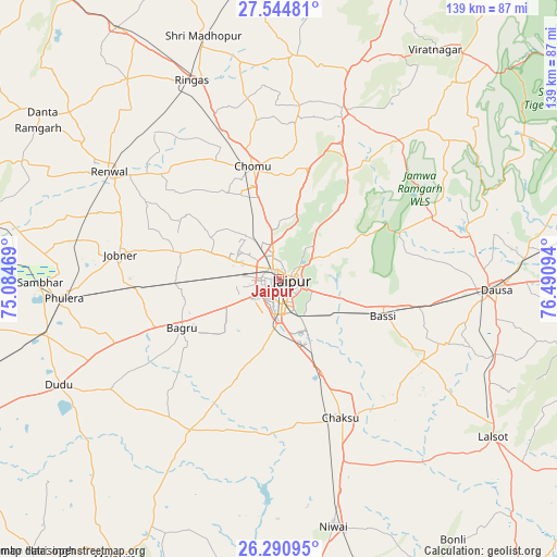
Jaipur GPS coordinates[2]
26° 55' 10.632" North, 75° 47' 16.116" East
| Map corner | latitude | longitude |
|---|---|---|
| Upper-left | 27.54481°, | 75.08469° |
| Center: | 26.91962°, | 75.78781° |
| Lower-right: | 26.29095°, | 76.49094° |
| Map W x H: | 139.4×139.4 km | = 86.6×86.6mi |
| max Lat: | 34.9274° ⇑22.1% North |
| Jaipur: | 26.91962° |
| min Lat: | ⇓77.9% South 8.09008° |
| min Long | Jaipur | max Long |
| 68.82655° | 75.78781° | 96.81° |
| W 24.2%⇐ | ⇒75.8% E |
Elevation
Elevation of Jaipur is 435 m = 1427 ft, and this is 139.4 m = 457 ft above average elevation for this country.
| Max E: |
3681 m = 12077 ft | 21.7% |
| Jaipur | 435 m 1427 ft | |
| Avg. | 295.6 m = 970 ft | |
Min E: |
1 m = 3 ft | 78.3% |
See also: Jaipur elevation on elevation.city.
Geographical zone
Jaipur is located in North temperate zone (between Tropic of Cancer and the Arctic Circle). Distance of this Northern Tropic circle is 387.3 km =240.7 mi to South.| Distance of | km | miles | from Jaipur |
|---|---|---|---|
| North Pole | 7013.9 | 4358.2 | to North |
| Arctic Circle | 4408 | 2739 | to North |
| Tropic Cancer | 387.3 | 240.7 | to South |
| Equator | 2993.2 | 1859.9 | to South |


Nearby cities:
15 places around Jaipur: (largest is in red/bold)
• Basi
27.7 km =17.2 mi,  110°
110°
• Chaksu
38.4 km =23.9 mi,  155°
155°
• Dausa
54.4 km =33.8 mi,  93°
93°
• Jobner
40.1 km =24.9 mi,  278°
278°
• Lālsot
67 km =41.6 mi,  126°
126°
• Manoharpur
45 km =28 mi,  20°
20°
• Naraina
59.5 km =37 mi,  256°
256°
• Niwai
63.5 km =39.5 mi,  168°
168°
• Nāwa
78.6 km =48.8 mi, 278°
• Phulera
54.4 km =33.8 mi, 264°
• Rāmgarh
70.6 km =43.9 mi,  301°
301°
• Rīngas
53.9 km =33.5 mi,  336°
336°
• Shāhpura
55.1 km =34.2 mi, 17°
• Sri Mādhopur
63.6 km =39.5 mi, 342°
• Sāmbhar
59.1 km =36.7 mi,  268°
268°
Sources, notices
• [Note1] Compared only with cities in India existing in our database
• [Src1] Map data: © OpenStreetMap contributors (CC-BY-SA)
• [Src2] Other city data from geonames.org with taken over terms of usage.
• [Src3] Geographical zone / Annual Mean Temperature by Robert A. Rohde @ Wikipedia
