Neem ka Thana geodata
Neem ka Thana (Rajasthan) is a populated place; located in India in Asia/Kolkata (GMT+5.5) time zone. With population of 32,690 people, there are 1334 cities with bigger population in this country. Compared to other cities in India, 83.4% of cities are located further ↓South; 75.9% of cities are located further →East and 79.9% of cities have lower elevation than Neem ka Thana. Note1


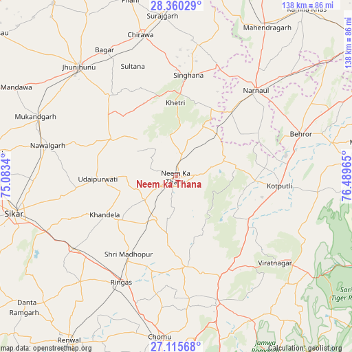
Neem ka Thana GPS coordinates[2]
27° 44' 23.136" North, 75° 47' 11.472" East
| Map corner | latitude | longitude |
|---|---|---|
| Upper-left | 28.36029°, | 75.0834° |
| Center: | 27.73976°, | 75.78652° |
| Lower-right: | 27.11568°, | 76.48965° |
| Map W x H: | 138.4×138.4 km | = 86×86mi |
| max Lat: | 34.9274° ⇑16.6% North |
| Neem ka Thana: | 27.73976° |
| min Lat: | ⇓83.4% South 8.09008° |
| min Long | Neem ka Thana | max Long |
| 68.82655° | 75.78652° | 96.81° |
| W 24.1%⇐ | ⇒75.9% E |
Elevation
Elevation of Neem ka Thana is 458 m = 1503 ft, and this is 162.4 m = 533 ft above average elevation for this country.
| Max E: |
3681 m = 12077 ft | 20.1% |
| Neem ka Thana | 458 m 1503 ft | |
| Avg. | 295.6 m = 970 ft | |
Min E: |
1 m = 3 ft | 79.9% |
See also: India elevation on elevation.city.
Geographical zone
Neem ka Thana is located in North temperate zone (between Tropic of Cancer and the Arctic Circle). Distance of this Northern Tropic circle is 478.5 km =297.3 mi to South.| Distance of | km | miles | from Neem ka Thana |
|---|---|---|---|
| North Pole | 6922.7 | 4301.6 | to North |
| Arctic Circle | 4316.8 | 2682.3 | to North |
| Tropic Cancer | 478.5 | 297.3 | to South |
| Equator | 3084.4 | 1916.6 | to South |


Nearby cities:
15 places around Neem ka Thana: (largest is in red/bold)
• Ateli Mandi
61.4 km =38.2 mi,  49°
49°
• Bagar
57.2 km =35.5 mi,  330°
330°
• Behror
51.4 km =31.9 mi,  71°
71°
• Chidawa
57.4 km =35.7 mi,  345°
345°
• Jhunjhunūn
57.4 km =35.7 mi,  318°
318°
• Khandela
31.8 km =19.8 mi,  241°
241°
• Khetri
29 km =18 mi,  359°
359°
• Kotputli
40.8 km =25.4 mi,  95°
95°
• Manoharpur
51.7 km =32.1 mi,  161°
161°
• Nawalgarh
51.9 km =32.2 mi,  283°
283°
• Nārnaul
46.3 km =28.8 mi,  43°
43°
• Rīngas
47 km =29.2 mi,  207°
207°
• Shāhpura
42.3 km =26.3 mi, 156°
• Sri Mādhopur
35.7 km =22.2 mi, 211°
• Udaipur
31 km =19.3 mi,  266°
266°
Sources, notices
• [Note1] Compared only with cities in India existing in our database
• [Src1] Map data: © OpenStreetMap contributors (CC-BY-SA)
• [Src2] Other city data from geonames.org with taken over terms of usage.
• [Src3] Geographical zone / Annual Mean Temperature by Robert A. Rohde @ Wikipedia
