Shāhpura geodata
Shāhpura (Rajasthan) is a populated place; located in India in Asia/Kolkata (GMT+5.5) time zone. With population of 33,273 people, there are 1308 cities with bigger population in this country. Compared to other cities in India, 81.1% of cities are located further ↓South; 74% of cities are located further →East and 78.5% of cities have lower elevation than Shāhpura. Note1


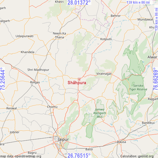
Shāhpura GPS coordinates[2]
27° 23' 28.32" North, 75° 57' 34.416" East
| Map corner | latitude | longitude |
|---|---|---|
| Upper-left | 28.01372°, | 75.25644° |
| Center: | 27.3912°, | 75.95956° |
| Lower-right: | 26.76515°, | 76.66269° |
| Map W x H: | 138.8×138.8 km | = 86.2×86.2mi |
| max Lat: | 34.9274° ⇑18.9% North |
| Shāhpura: | 27.3912° |
| min Lat: | ⇓81.1% South 8.09008° |
| min Long | Shāhpura | max Long |
| 68.82655° | 75.95956° | 96.81° |
| W 26%⇐ | ⇒74% E |
Elevation
Elevation of Shāhpura is 438 m = 1437 ft, and this is 142.4 m = 467 ft above average elevation for this country.
| Max E: |
3681 m = 12077 ft | 21.5% |
| Shāhpura | 438 m 1437 ft | |
| Avg. | 295.6 m = 970 ft | |
Min E: |
1 m = 3 ft | 78.5% |
See also: India elevation on elevation.city.
Geographical zone
Shāhpura is located in North temperate zone (between Tropic of Cancer and the Arctic Circle). Distance of this Northern Tropic circle is 439.7 km =273.2 mi to South.| Distance of | km | miles | from Shāhpura |
|---|---|---|---|
| North Pole | 6961.4 | 4325.6 | to North |
| Arctic Circle | 4355.6 | 2706.4 | to North |
| Tropic Cancer | 439.7 | 273.2 | to South |
| Equator | 3045.6 | 1892.4 | to South |


Nearby cities:
15 places around Shāhpura: (largest is in red/bold)
• Alwar
68.3 km =42.4 mi,  73°
73°
• Basi
62.9 km =39.1 mi,  171°
171°
• Baswa
67.3 km =41.8 mi,  113°
113°
• Behror
63.7 km =39.6 mi,  29°
29°
• Dausa
67 km =41.6 mi,  146°
146°
• Jaipur
55.1 km =34.2 mi,  197°
197°
• Khandela
51 km =31.7 mi,  297°
297°
• Khetri
69.9 km =43.4 mi,  345°
345°
• Kotputli
41.9 km =26 mi, 34°
• Manoharpur
10.4 km =6.5 mi,  185°
185°
• Neem ka Thana
42.3 km =26.3 mi,  336°
336°
• Rājgarh
67.7 km =42.1 mi,  104°
104°
• Rīngas
38.7 km =24 mi,  265°
265°
• Sri Mādhopur
36.7 km =22.8 mi,  283°
283°
• Udaipur
60.6 km =37.7 mi,  307°
307°
Sources, notices
• [Note1] Compared only with cities in India existing in our database
• [Src1] Map data: © OpenStreetMap contributors (CC-BY-SA)
• [Src2] Other city data from geonames.org with taken over terms of usage.
• [Src3] Geographical zone / Annual Mean Temperature by Robert A. Rohde @ Wikipedia
