Manoharpur geodata
Manoharpur (Rajasthan) is a populated place; located in India in Asia/Kolkata (GMT+5.5) time zone. With population of 28,928 people, there are 1500 cities with bigger population in this country. Compared to other cities in India, 80.8% of cities are located further ↓South; 74.1% of cities are located further →East and 79.8% of cities have lower elevation than Manoharpur. Note1


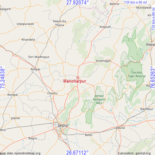
Manoharpur GPS coordinates[2]
27° 17' 51.684" North, 75° 56' 58.2" East
| Map corner | latitude | longitude |
|---|---|---|
| Upper-left | 27.92074°, | 75.24638° |
| Center: | 27.29769°, | 75.9495° |
| Lower-right: | 26.67112°, | 76.65263° |
| Map W x H: | 138.9×138.9 km | = 86.3×86.3mi |
| max Lat: | 34.9274° ⇑19.2% North |
| Manoharpur: | 27.29769° |
| min Lat: | ⇓80.8% South 8.09008° |
| min Long | Manoharpur | max Long |
| 68.82655° | 75.9495° | 96.81° |
| W 25.9%⇐ | ⇒74.1% E |
Elevation
Elevation of Manoharpur is 456 m = 1496 ft, and this is 160.4 m = 526 ft above average elevation for this country.
| Max E: |
3681 m = 12077 ft | 20.2% |
| Manoharpur | 456 m 1496 ft | |
| Avg. | 295.6 m = 970 ft | |
Min E: |
1 m = 3 ft | 79.8% |
See also: India elevation on elevation.city.
Geographical zone
Manoharpur is located in North temperate zone (between Tropic of Cancer and the Arctic Circle). Distance of this Northern Tropic circle is 429.3 km =266.8 mi to South.| Distance of | km | miles | from Manoharpur |
|---|---|---|---|
| North Pole | 6971.8 | 4332.1 | to North |
| Arctic Circle | 4366 | 2712.9 | to North |
| Tropic Cancer | 429.3 | 266.8 | to South |
| Equator | 3035.2 | 1886 | to South |


Nearby cities:
15 places around Manoharpur: (largest is in red/bold)
• Abhaneri
72.7 km =45.2 mi,  116°
116°
• Basi
52.8 km =32.8 mi,  169°
169°
• Baswa
64.8 km =40.3 mi,  104°
104°
• Bāndīkūi
67.5 km =41.9 mi,  113°
113°
• Dausa
59.3 km =36.8 mi,  139°
139°
• Jaipur
45 km =28 mi,  200°
200°
• Jobner
66.3 km =41.2 mi,  236°
236°
• Khandela
55.8 km =34.7 mi,  307°
307°
• Kotputli
51.3 km =31.9 mi,  28°
28°
• Neem ka Thana
51.7 km =32.1 mi,  341°
341°
• Rājgarh
66.8 km =41.5 mi, 95°
• Rīngas
38.4 km =23.9 mi,  281°
281°
• Shāhpura
10.4 km =6.5 mi,  5°
5°
• Sri Mādhopur
39.5 km =24.5 mi,  298°
298°
• Udaipur
66.7 km =41.4 mi,  315°
315°
Sources, notices
• [Note1] Compared only with cities in India existing in our database
• [Src1] Map data: © OpenStreetMap contributors (CC-BY-SA)
• [Src2] Other city data from geonames.org with taken over terms of usage.
• [Src3] Geographical zone / Annual Mean Temperature by Robert A. Rohde @ Wikipedia
