Mahendragarh geodata
Mahendragarh (Haryana) is a populated place; located in India in Asia/Kolkata (GMT+5.5) time zone. With population of 25,728 people, there are 1654 cities with bigger population in this country. Compared to other cities in India, 85.8% of cities are located further ↓South; 72.1% of cities are located further →East and 63.7% of cities have lower elevation than Mahendragarh. Note1


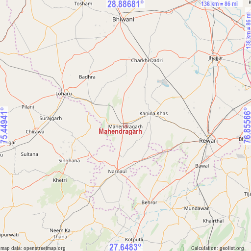
Mahendragarh GPS coordinates[2]
28° 16' 9.66" North, 76° 9' 9.108" East
| Map corner | latitude | longitude |
|---|---|---|
| Upper-left | 28.88681°, | 75.44941° |
| Center: | 28.26935°, | 76.15253° |
| Lower-right: | 27.6483°, | 76.85566° |
| Map W x H: | 137.7×137.7 km | = 85.6×85.6mi |
| max Lat: | 34.9274° ⇑14.2% North |
| Mahendragarh: | 28.26935° |
| min Lat: | ⇓85.8% South 8.09008° |
| min Long | Mahendragarh | max Long |
| 68.82655° | 76.15253° | 96.81° |
| W 27.9%⇐ | ⇒72.1% E |
Elevation
Elevation of Mahendragarh is 276 m = 906 ft, and this is 19.6 m = 64 ft below average elevation for this country.
| Max E: |
3681 m = 12077 ft | 36.3% |
| Avg. | 295.6 m = 970 ft | |
| Mahendragarh | 276 m = 906 ft | |
Min E: |
1 m = 3 ft | 63.7% |
See also: India elevation on elevation.city.
Geographical zone
Mahendragarh is located in North temperate zone (between Tropic of Cancer and the Arctic Circle). Distance of this Northern Tropic circle is 537.3 km =333.9 mi to South.| Distance of | km | miles | from Mahendragarh |
|---|---|---|---|
| North Pole | 6863.8 | 4265 | to North |
| Arctic Circle | 4257.9 | 2645.7 | to North |
| Tropic Cancer | 537.3 | 333.9 | to South |
| Equator | 3143.3 | 1953.2 | to South |


Nearby cities:
15 places around Mahendragarh: (largest is in red/bold)
• Ateli Mandi
21.5 km =13.4 mi,  150°
150°
• Behror
44.2 km =27.5 mi,  163°
163°
• Bhiwāni
58.2 km =36.2 mi,  358°
358°
• Bāwal
47.6 km =29.6 mi,  117°
117°
• Charkhi Dādri
37.7 km =23.4 mi,  17°
17°
• Chidawa
50.3 km =31.3 mi,  266°
266°
• Kanīna Khās
17 km =10.6 mi,  66°
66°
• Khetri
46.7 km =29 mi,  230°
230°
• Lohāru
38.2 km =23.7 mi,  297°
297°
• Mandāwar
59.6 km =37 mi,  139°
139°
• Nārnaul
25.4 km =15.8 mi,  189°
189°
• Pataudi
61.6 km =38.3 mi,  84°
84°
• Pilāni
54.8 km =34.1 mi,  281°
281°
• Rewāri
46.3 km =28.8 mi,  99°
99°
• Sūrajgarh
41.4 km =25.7 mi, 276°
Sources, notices
• [Note1] Compared only with cities in India existing in our database
• [Src1] Map data: © OpenStreetMap contributors (CC-BY-SA)
• [Src2] Other city data from geonames.org with taken over terms of usage.
• [Src3] Geographical zone / Annual Mean Temperature by Robert A. Rohde @ Wikipedia
