Kanīna Khās geodata
Kanīna Khās (Haryana) is a populated place; located in India in Asia/Kolkata (GMT+5.5) time zone. With population of 10,815 people, there are 2852 cities with bigger population in this country. Compared to other cities in India, 86.1% of cities are located further ↓South; 70.5% of cities are located further →East and 60.5% of cities have lower elevation than Kanīna Khās. Note1


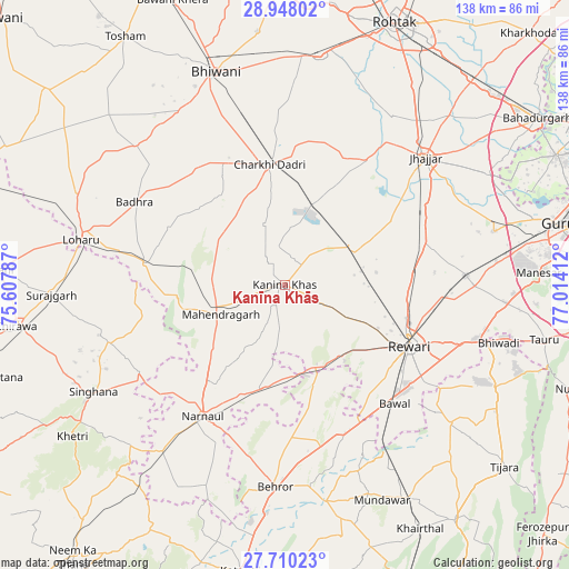
Kanīna Khās GPS coordinates[2]
28° 19' 51.348" North, 76° 18' 39.564" East
| Map corner | latitude | longitude |
|---|---|---|
| Upper-left | 28.94802°, | 75.60787° |
| Center: | 28.33093°, | 76.31099° |
| Lower-right: | 27.71023°, | 77.01412° |
| Map W x H: | 137.6×137.6 km | = 85.5×85.5mi |
| max Lat: | 34.9274° ⇑13.9% North |
| Kanīna Khās: | 28.33093° |
| min Lat: | ⇓86.1% South 8.09008° |
| min Long | Kanīna Khās | max Long |
| 68.82655° | 76.31099° | 96.81° |
| W 29.5%⇐ | ⇒70.5% E |
Elevation
Elevation of Kanīna Khās is 255 m = 837 ft, and this is 40.6 m = 133 ft below average elevation for this country.
| Max E: |
3681 m = 12077 ft | 39.5% |
| Avg. | 295.6 m = 970 ft | |
| Kanīna Khās | 255 m = 837 ft | |
Min E: |
1 m = 3 ft | 60.5% |
See also: India elevation on elevation.city.
Geographical zone
Kanīna Khās is located in North temperate zone (between Tropic of Cancer and the Arctic Circle). Distance of this Northern Tropic circle is 544.2 km =338.2 mi to South.| Distance of | km | miles | from Kanīna Khās |
|---|---|---|---|
| North Pole | 6857 | 4260.7 | to North |
| Arctic Circle | 4251.1 | 2641.5 | to North |
| Tropic Cancer | 544.2 | 338.2 | to South |
| Equator | 3150.1 | 1957.4 | to South |


Nearby cities:
15 places around Kanīna Khās: (largest is in red/bold)
• Ateli Mandi
26.1 km =16.2 mi,  191°
191°
• Behror
49.3 km =30.6 mi,  183°
183°
• Beri Khās
48.7 km =30.3 mi,  32°
32°
• Bhiwadi
55.5 km =34.5 mi,  104°
104°
• Bhiwāni
54 km =33.6 mi,  341°
341°
• Bāwal
39.3 km =24.4 mi,  137°
137°
• Charkhi Dādri
29.2 km =18.1 mi,  352°
352°
• Dhāruhera
49.6 km =30.8 mi,  106°
106°
• Farrukhnagar
51.8 km =32.2 mi,  75°
75°
• Jhajjar
45.6 km =28.3 mi,  47°
47°
• Lohāru
50.4 km =31.3 mi,  282°
282°
• Mahendragarh
17 km =10.6 mi,  246°
246°
• Nārnaul
37.5 km =23.3 mi,  211°
211°
• Pataudi
45.8 km =28.5 mi,  90°
90°
• Rewāri
33.5 km =20.8 mi,  115°
115°
Sources, notices
• [Note1] Compared only with cities in India existing in our database
• [Src1] Map data: © OpenStreetMap contributors (CC-BY-SA)
• [Src2] Other city data from geonames.org with taken over terms of usage.
• [Src3] Geographical zone / Annual Mean Temperature by Robert A. Rohde @ Wikipedia
