Jhajjar geodata
Jhajjar (Haryana) is a populated place; located in India in Asia/Kolkata (GMT+5.5) time zone. With population of 44,122 people, there are 1003 cities with bigger population in this country. Compared to other cities in India, 87.2% of cities are located further ↓South; 66.7% of cities are located further →East and 54.5% of cities have lower elevation than Jhajjar. Note1


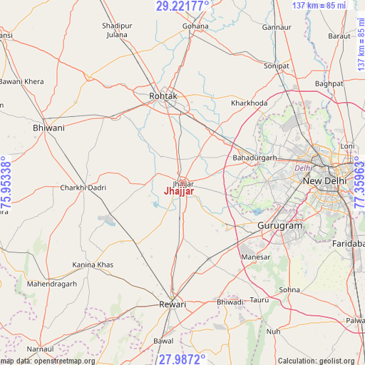
Jhajjar GPS coordinates[2]
28° 36' 22.68" North, 76° 39' 23.4" East
| Map corner | latitude | longitude |
|---|---|---|
| Upper-left | 29.22177°, | 75.95338° |
| Center: | 28.6063°, | 76.6565° |
| Lower-right: | 27.9872°, | 77.35963° |
| Map W x H: | 137.3×137.3 km | = 85.3×85.3mi |
| max Lat: | 34.9274° ⇑12.8% North |
| Jhajjar: | 28.6063° |
| min Lat: | ⇓87.2% South 8.09008° |
| min Long | Jhajjar | max Long |
| 68.82655° | 76.6565° | 96.81° |
| W 33.3%⇐ | ⇒66.7% E |
Elevation
Elevation of Jhajjar is 224 m = 735 ft, and this is 71.6 m = 235 ft below average elevation for this country.
| Max E: |
3681 m = 12077 ft | 45.5% |
| Avg. | 295.6 m = 970 ft | |
| Jhajjar | 224 m = 735 ft | |
Min E: |
1 m = 3 ft | 54.5% |
See also: Jhajjar elevation on elevation.city.
Geographical zone
Jhajjar is located in North temperate zone (between Tropic of Cancer and the Arctic Circle). Distance of this Northern Tropic circle is 574.8 km =357.2 mi to South.| Distance of | km | miles | from Jhajjar |
|---|---|---|---|
| North Pole | 6826.3 | 4241.7 | to North |
| Arctic Circle | 4220.5 | 2622.5 | to North |
| Tropic Cancer | 574.8 | 357.2 | to South |
| Equator | 3180.7 | 1976.4 | to South |


Nearby cities:
15 places around Jhajjar: (largest is in red/bold)
• Bahādurgarh
28.9 km =18 mi,  70°
70°
• Bawāna
42.6 km =26.5 mi,  59°
59°
• Beri Khās
13.1 km =8.1 mi,  323°
323°
• Charkhi Dādri
37.6 km =23.4 mi,  267°
267°
• Farrukhnagar
24.1 km =15 mi,  137°
137°
• Gurgaon
39.6 km =24.6 mi,  114°
114°
• Kalānaur
35.4 km =22 mi,  314°
314°
• Kharkhauda
39.1 km =24.3 mi,  39°
39°
• Kheri Sāmpla
22.4 km =13.9 mi,  31°
31°
• Najafgarh
31.6 km =19.6 mi,  89°
89°
• Nāngloi Jāt
41 km =25.5 mi,  78°
78°
• Pataudi
33.4 km =20.8 mi,  159°
159°
• Rewāri
45.4 km =28.2 mi,  184°
184°
• Rohini
42.9 km =26.7 mi, 69°
• Rohtak
32.7 km =20.3 mi,  348°
348°
Sources, notices
• [Note1] Compared only with cities in India existing in our database
• [Src1] Map data: © OpenStreetMap contributors (CC-BY-SA)
• [Src2] Other city data from geonames.org with taken over terms of usage.
• [Src3] Geographical zone / Annual Mean Temperature by Robert A. Rohde @ Wikipedia
