Rāīwāla Bara geodata
Rāīwāla Bara (Uttarakhand) is a populated place; located in India in Asia/Kolkata (GMT+5.5) time zone. With population of 5,198 people, there are 3332 cities with bigger population in this country. Compared to other cities in India, 92.8% of cities are located further ↓South; 51.5% of cities are located further ←West and 69.3% of cities have lower elevation than Rāīwāla Bara. Note1


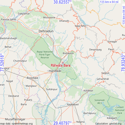
Rāīwāla Bara GPS coordinates[2]
30° 1' 7.104" North, 78° 13' 45.48" East
| Map corner | latitude | longitude |
|---|---|---|
| Upper-left | 30.62557°, | 77.52618° |
| Center: | 30.01864°, | 78.2293° |
| Lower-right: | 29.40797°, | 78.93243° |
| Map W x H: | 135.4×135.4 km | = 84.1×84.1mi |
| max Lat: | 34.9274° ⇑7.2% North |
| Rāīwāla Bara: | 30.01864° |
| min Lat: | ⇓92.8% South 8.09008° |
| min Long | Rāīwāla Bara | max Long |
| 68.82655° | 78.2293° | 96.81° |
| W 51.5%⇐ | ⇒48.5% E |
Elevation
Elevation of Rāīwāla Bara is 320 m = 1050 ft, and this is 24.4 m = 80 ft above average elevation for this country.
| Max E: |
3681 m = 12077 ft | 30.7% |
| Rāīwāla Bara | 320 m 1050 ft | |
| Avg. | 295.6 m = 970 ft | |
Min E: |
1 m = 3 ft | 69.3% |
See also: India elevation on elevation.city.
Geographical zone
Rāīwāla Bara is located in North temperate zone (between Tropic of Cancer and the Arctic Circle). Distance of this Northern Tropic circle is 731.8 km =454.7 mi to South.| Distance of | km | miles | from Rāīwāla Bara |
|---|---|---|---|
| North Pole | 6669.3 | 4144.1 | to North |
| Arctic Circle | 4063.4 | 2524.9 | to North |
| Tropic Cancer | 731.8 | 454.7 | to South |
| Equator | 3337.8 | 2074 | to South |


Nearby cities:
15 places around Rāīwāla Bara: (largest is in red/bold)
• Birbhaddar
7.7 km =4.8 mi,  40°
40°
• Clement Town
34.5 km =21.4 mi,  322°
322°
• Dehra Dūn
38.8 km =24.1 mi,  331°
331°
• Devaprayāg
38.6 km =24 mi,  68°
68°
• Doiwāla
20.6 km =12.8 mi, 328°
• Dugadda
43.7 km =27.2 mi,  122°
122°
• Haridwar
10.3 km =6.4 mi,  220°
220°
• Kotdwāra
41.4 km =25.7 mi,  137°
137°
• Laksar
34.1 km =21.2 mi,  212°
212°
• Manglaur
42.3 km =26.3 mi,  233°
233°
• Narendranagar
16.9 km =10.5 mi,  19°
19°
• Rishīkesh
11.6 km =7.2 mi,  31°
31°
• Roorkee
36.7 km =22.8 mi,  242°
242°
• Rāipur
35.2 km =21.9 mi,  337°
337°
• Sultānpur
31.4 km =19.5 mi,  201°
201°
Sources, notices
• [Note1] Compared only with cities in India existing in our database
• [Src1] Map data: © OpenStreetMap contributors (CC-BY-SA)
• [Src2] Other city data from geonames.org with taken over terms of usage.
• [Src3] Geographical zone / Annual Mean Temperature by Robert A. Rohde @ Wikipedia
