Rishīkesh geodata
Rishīkesh (Uttarakhand) is a populated place; located in India in Asia/Kolkata (GMT+5.5) time zone. With population of 66,390 people, there are 654 cities with bigger population in this country. Compared to other cities in India, 93% of cities are located further ↓South; 52.3% of cities are located further ←West and 73% of cities have lower elevation than Rishīkesh. Note1


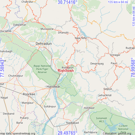
Rishīkesh GPS coordinates[2]
30° 6' 28.008" North, 78° 17' 33.18" East
| Map corner | latitude | longitude |
|---|---|---|
| Upper-left | 30.71416°, | 77.58943° |
| Center: | 30.10778°, | 78.29255° |
| Lower-right: | 29.49765°, | 78.99568° |
| Map W x H: | 135.3×135.3 km | = 84.1×84.1mi |
| max Lat: | 34.9274° ⇑7% North |
| Rishīkesh: | 30.10778° |
| min Lat: | ⇓93% South 8.09008° |
| min Long | Rishīkesh | max Long |
| 68.82655° | 78.29255° | 96.81° |
| W 52.3%⇐ | ⇒47.7% E |
Elevation
Elevation of Rishīkesh is 361 m = 1184 ft, and this is 65.4 m = 215 ft above average elevation for this country.
| Max E: |
3681 m = 12077 ft | 27% |
| Rishīkesh | 361 m 1184 ft | |
| Avg. | 295.6 m = 970 ft | |
Min E: |
1 m = 3 ft | 73% |
See also: Rishīkesh elevation on elevation.city.
Geographical zone
Rishīkesh is located in North temperate zone (between Tropic of Cancer and the Arctic Circle). Distance of this Northern Tropic circle is 741.8 km =460.9 mi to South.| Distance of | km | miles | from Rishīkesh |
|---|---|---|---|
| North Pole | 6659.4 | 4138 | to North |
| Arctic Circle | 4053.5 | 2518.7 | to North |
| Tropic Cancer | 741.8 | 460.9 | to South |
| Equator | 3347.7 | 2080.2 | to South |


Nearby cities:
15 places around Rishīkesh: (largest is in red/bold)
• Birbhaddar
4.2 km =2.6 mi,  194°
194°
• Clement Town
32.3 km =20.1 mi,  302°
302°
• Dehra Dūn
34.6 km =21.5 mi,  314°
314°
• Devaprayāg
30.1 km =18.7 mi,  81°
81°
• Doiwāla
18.6 km =11.6 mi,  294°
294°
• Dugadda
45.4 km =28.2 mi,  137°
137°
• Haridwar
21.9 km =13.6 mi,  215°
215°
• Kotdwāra
45.9 km =28.5 mi,  151°
151°
• Laksar
45.7 km =28.4 mi,  211°
211°
• Mussoorie
44.1 km =27.4 mi,  331°
331°
• Narendranagar
6 km =3.7 mi,  355°
355°
• Rāipur
29.8 km =18.5 mi,  319°
319°
• Rāīwāla Bara
11.6 km =7.2 mi, 211°
• Sultānpur
42.9 km =26.7 mi,  204°
204°
• Tehri
36.3 km =22.6 mi,  29°
29°
Sources, notices
• [Note1] Compared only with cities in India existing in our database
• [Src1] Map data: © OpenStreetMap contributors (CC-BY-SA)
• [Src2] Other city data from geonames.org with taken over terms of usage.
• [Src3] Geographical zone / Annual Mean Temperature by Robert A. Rohde @ Wikipedia
