Devaprayāg geodata
Devaprayāg (Uttarakhand) is a populated place; located in India in Asia/Kolkata (GMT+5.5) time zone. With population of 2,130 people, there are 3429 cities with bigger population in this country. Compared to other cities in India, 93.2% of cities are located further ↓South; 55.2% of cities are located further ←West and 89% of cities have lower elevation than Devaprayāg. Note1


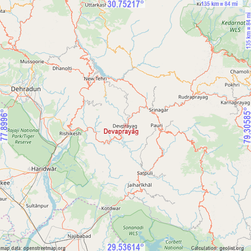
Devaprayāg GPS coordinates[2]
30° 8' 45.708" North, 78° 36' 9.792" East
| Map corner | latitude | longitude |
|---|---|---|
| Upper-left | 30.75217°, | 77.8996° |
| Center: | 30.14603°, | 78.60272° |
| Lower-right: | 29.53614°, | 79.30585° |
| Map W x H: | 135.2×135.2 km | = 84×84mi |
| max Lat: | 34.9274° ⇑6.8% North |
| Devaprayāg: | 30.14603° |
| min Lat: | ⇓93.2% South 8.09008° |
| min Long | Devaprayāg | max Long |
| 68.82655° | 78.60272° | 96.81° |
| W 55.2%⇐ | ⇒44.8% E |
Elevation
Elevation of Devaprayāg is 615 m = 2018 ft, and this is 319.4 m = 1048 ft above average elevation for this country.
| Max E: |
3681 m = 12077 ft | 11% |
| Devaprayāg | 615 m 2018 ft | |
| Avg. | 295.6 m = 970 ft | |
Min E: |
1 m = 3 ft | 89% |
See also: India elevation on elevation.city.
Geographical zone
Devaprayāg is located in North temperate zone (between Tropic of Cancer and the Arctic Circle). Distance of this Northern Tropic circle is 746 km =463.5 mi to South.| Distance of | km | miles | from Devaprayāg |
|---|---|---|---|
| North Pole | 6655.1 | 4135.3 | to North |
| Arctic Circle | 4049.2 | 2516.1 | to North |
| Tropic Cancer | 746 | 463.5 | to South |
| Equator | 3351.9 | 2082.8 | to South |


Nearby cities:
15 places around Devaprayāg: (largest is in red/bold)
• Birbhaddar
32 km =19.9 mi,  254°
254°
• Dehra Dūn
58.1 km =36.1 mi,  289°
289°
• Doiwāla
46.9 km =29.1 mi,  274°
274°
• Dugadda
37.7 km =23.4 mi,  178°
178°
• Haridwar
47.9 km =29.8 mi,  242°
242°
• Kotdwāra
45.1 km =28 mi,  189°
189°
• Lansdowne
34.6 km =21.5 mi,  167°
167°
• Narendranagar
30.4 km =18.9 mi, 273°
• Pauri
16.8 km =10.4 mi,  87°
87°
• Rishīkesh
30.1 km =18.7 mi,  261°
261°
• Rudraprayāg
39.7 km =24.7 mi,  67°
67°
• Rāipur
52.6 km =32.7 mi, 290°
• Rāīwāla Bara
38.6 km =24 mi, 248°
• Srīnagar
19.3 km =12 mi,  63°
63°
• Tehri
29.7 km =18.5 mi,  336°
336°
Sources, notices
• [Note1] Compared only with cities in India existing in our database
• [Src1] Map data: © OpenStreetMap contributors (CC-BY-SA)
• [Src2] Other city data from geonames.org with taken over terms of usage.
• [Src3] Geographical zone / Annual Mean Temperature by Robert A. Rohde @ Wikipedia
