Laksar geodata
Laksar (Uttarakhand) is a populated place; located in India in Asia/Kolkata (GMT+5.5) time zone. With population of 19,270 people, there are 2103 cities with bigger population in this country. Compared to other cities in India, 92% of cities are located further ↓South; 50.9% of cities are located further →East and 58.1% of cities have lower elevation than Laksar. Note1


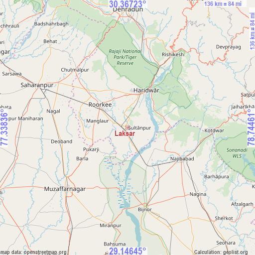
Laksar GPS coordinates[2]
29° 45' 31.32" North, 78° 2' 29.328" East
| Map corner | latitude | longitude |
|---|---|---|
| Upper-left | 30.36723°, | 77.33836° |
| Center: | 29.7587°, | 78.04148° |
| Lower-right: | 29.14645°, | 78.74461° |
| Map W x H: | 135.7×135.7 km | = 84.3×84.3mi |
| max Lat: | 34.9274° ⇑8% North |
| Laksar: | 29.7587° |
| min Lat: | ⇓92% South 8.09008° |
| min Long | Laksar | max Long |
| 68.82655° | 78.04148° | 96.81° |
| W 49.1%⇐ | ⇒50.9% E |
Elevation
Elevation of Laksar is 240 m = 787 ft, and this is 55.6 m = 182 ft below average elevation for this country.
| Max E: |
3681 m = 12077 ft | 41.9% |
| Avg. | 295.6 m = 970 ft | |
| Laksar | 240 m = 787 ft | |
Min E: |
1 m = 3 ft | 58.1% |
See also: India elevation on elevation.city.
Geographical zone
Laksar is located in North temperate zone (between Tropic of Cancer and the Arctic Circle). Distance of this Northern Tropic circle is 702.9 km =436.8 mi to South.| Distance of | km | miles | from Laksar |
|---|---|---|---|
| North Pole | 6698.2 | 4162.1 | to North |
| Arctic Circle | 4092.3 | 2542.8 | to North |
| Tropic Cancer | 702.9 | 436.8 | to South |
| Equator | 3308.9 | 2056.1 | to South |


Nearby cities:
15 places around Laksar: (largest is in red/bold)
• Bijnor
43.9 km =27.3 mi,  167°
167°
• Birbhaddar
41.8 km =26 mi,  33°
33°
• Chhutmalpur
41.2 km =25.6 mi,  317°
317°
• Deoband
35.6 km =22.1 mi,  258°
258°
• Haridwar
24 km =14.9 mi, 28°
• Kotdwāra
46.4 km =28.8 mi,  91°
91°
• Kīratpur
32.2 km =20 mi,  150°
150°
• Mandāwar
31.4 km =19.5 mi,  164°
164°
• Manglaur
16.1 km =10 mi,  282°
282°
• Muzaffarnagar
45.7 km =28.4 mi,  225°
225°
• Najībābād
33.4 km =20.8 mi,  119°
119°
• Rishīkesh
45.7 km =28.4 mi, 31°
• Roorkee
18.8 km =11.7 mi,  309°
309°
• Rāīwāla Bara
34.1 km =21.2 mi, 32°
• Sultānpur
6.7 km =4.2 mi, 93°
Sources, notices
• [Note1] Compared only with cities in India existing in our database
• [Src1] Map data: © OpenStreetMap contributors (CC-BY-SA)
• [Src2] Other city data from geonames.org with taken over terms of usage.
• [Src3] Geographical zone / Annual Mean Temperature by Robert A. Rohde @ Wikipedia
