Narendranagar geodata
Narendranagar (Uttarakhand) is a populated place; located in India in Asia/Kolkata (GMT+5.5) time zone. With population of 4,734 people, there are 3352 cities with bigger population in this country. Compared to other cities in India, 93.2% of cities are located further ↓South; 52.3% of cities are located further ←West and 95.4% of cities have lower elevation than Narendranagar. Note1


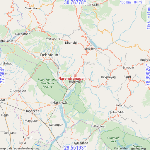
Narendranagar GPS coordinates[2]
30° 9' 42.228" North, 78° 17' 13.632" East
| Map corner | latitude | longitude |
|---|---|---|
| Upper-left | 30.76778°, | 77.584° |
| Center: | 30.16173°, | 78.28712° |
| Lower-right: | 29.55193°, | 78.99025° |
| Map W x H: | 135.2×135.2 km | = 84×84mi |
| max Lat: | 34.9274° ⇑6.8% North |
| Narendranagar: | 30.16173° |
| min Lat: | ⇓93.2% South 8.09008° |
| min Long | Narendranagar | max Long |
| 68.82655° | 78.28712° | 96.81° |
| W 52.3%⇐ | ⇒47.7% E |
Elevation
Elevation of Narendranagar is 911 m = 2989 ft, and this is 615.4 m = 2019 ft above average elevation for this country.
| Max E: |
3681 m = 12077 ft | 4.6% |
| Narendranagar | 911 m 2989 ft | |
| Avg. | 295.6 m = 970 ft | |
Min E: |
1 m = 3 ft | 95.4% |
See also: India elevation on elevation.city.
Geographical zone
Narendranagar is located in North temperate zone (between Tropic of Cancer and the Arctic Circle). Distance of this Northern Tropic circle is 747.8 km =464.7 mi to South.| Distance of | km | miles | from Narendranagar |
|---|---|---|---|
| North Pole | 6653.4 | 4134.2 | to North |
| Arctic Circle | 4047.5 | 2515 | to North |
| Tropic Cancer | 747.8 | 464.7 | to South |
| Equator | 3353.7 | 2083.9 | to South |


Nearby cities:
15 places around Narendranagar: (largest is in red/bold)
• Birbhaddar
10.1 km =6.3 mi,  182°
182°
• Clement Town
29.1 km =18.1 mi,  292°
292°
• Dehra Dūn
30.3 km =18.8 mi,  306°
306°
• Devaprayāg
30.4 km =18.9 mi,  93°
93°
• Doiwāla
16.5 km =10.3 mi,  275°
275°
• Dugadda
50.3 km =31.3 mi,  141°
141°
• Haridwar
26.7 km =16.6 mi,  207°
207°
• Mussoorie
38.7 km =24 mi,  327°
327°
• Pauri
47.1 km =29.3 mi, 91°
• Rishīkesh
6 km =3.7 mi, 175°
• Rāipur
25.2 km =15.7 mi, 311°
• Rāīwāla Bara
16.9 km =10.5 mi,  199°
199°
• Srīnagar
48.2 km =30 mi,  81°
81°
• Sultānpur
48.3 km =30 mi, 200°
• Tehri
31.5 km =19.6 mi,  36°
36°
Sources, notices
• [Note1] Compared only with cities in India existing in our database
• [Src1] Map data: © OpenStreetMap contributors (CC-BY-SA)
• [Src2] Other city data from geonames.org with taken over terms of usage.
• [Src3] Geographical zone / Annual Mean Temperature by Robert A. Rohde @ Wikipedia
