Kotdwāra geodata
Kotdwāra (Uttarakhand) is a populated place; located in India in Asia/Kolkata (GMT+5.5) time zone. With population of 27,009 people, there are 1584 cities with bigger population in this country. Compared to other cities in India, 91.9% of cities are located further ↓South; 54.4% of cities are located further ←West and 74.8% of cities have lower elevation than Kotdwāra. Note1


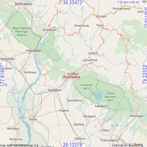
Kotdwāra GPS coordinates[2]
29° 44' 46.032" North, 78° 31' 19.884" East
| Map corner | latitude | longitude |
|---|---|---|
| Upper-left | 30.35473°, | 77.81907° |
| Center: | 29.74612°, | 78.52219° |
| Lower-right: | 29.13379°, | 79.22532° |
| Map W x H: | 135.8×135.8 km | = 84.4×84.4mi |
| max Lat: | 34.9274° ⇑8.1% North |
| Kotdwāra: | 29.74612° |
| min Lat: | ⇓91.9% South 8.09008° |
| min Long | Kotdwāra | max Long |
| 68.82655° | 78.52219° | 96.81° |
| W 54.4%⇐ | ⇒45.6% E |
Elevation
Elevation of Kotdwāra is 383 m = 1257 ft, and this is 87.4 m = 287 ft above average elevation for this country.
| Max E: |
3681 m = 12077 ft | 25.2% |
| Kotdwāra | 383 m 1257 ft | |
| Avg. | 295.6 m = 970 ft | |
Min E: |
1 m = 3 ft | 74.8% |
See also: India elevation on elevation.city.
Geographical zone
Kotdwāra is located in North temperate zone (between Tropic of Cancer and the Arctic Circle). Distance of this Northern Tropic circle is 701.5 km =435.9 mi to South.| Distance of | km | miles | from Kotdwāra |
|---|---|---|---|
| North Pole | 6699.6 | 4162.9 | to North |
| Arctic Circle | 4093.7 | 2543.7 | to North |
| Tropic Cancer | 701.5 | 435.9 | to South |
| Equator | 3307.5 | 2055.2 | to South |


Nearby cities:
15 places around Kotdwāra: (largest is in red/bold)
• Afzalgarh
41.8 km =26 mi,  159°
159°
• Birbhaddar
42.9 km =26.7 mi,  327°
327°
• Devaprayāg
45.1 km =28 mi,  9°
9°
• Dugadda
10.9 km =6.8 mi,  51°
51°
• Haridwar
41.5 km =25.8 mi,  302°
302°
• Kālāgarh Project Colony
39.2 km =24.4 mi,  139°
139°
• Kīratpur
40.5 km =25.2 mi,  228°
228°
• Laksar
46.4 km =28.8 mi,  271°
271°
• Lansdowne
18.6 km =11.6 mi,  55°
55°
• Nagīna
34.6 km =21.5 mi,  193°
193°
• Najībābād
22.9 km =14.2 mi, 229°
• Rishīkesh
45.9 km =28.5 mi, 331°
• Rāīwāla Bara
41.4 km =25.7 mi,  317°
317°
• Sherkot
46.9 km =29.1 mi,  173°
173°
• Sultānpur
39.8 km =24.7 mi, 271°
Sources, notices
• [Note1] Compared only with cities in India existing in our database
• [Src1] Map data: © OpenStreetMap contributors (CC-BY-SA)
• [Src2] Other city data from geonames.org with taken over terms of usage.
• [Src3] Geographical zone / Annual Mean Temperature by Robert A. Rohde @ Wikipedia
