Haridwar geodata
Haridwar (Uttarakhand) is a populated place; located in India in Asia/Kolkata (GMT+5.5) time zone. With population of 186,079 people, there are 226 cities with bigger population in this country. Compared to other cities in India, 92.6% of cities are located further ↓South; 50.8% of cities are located further ←West and 66.2% of cities have lower elevation than Haridwar. Note1


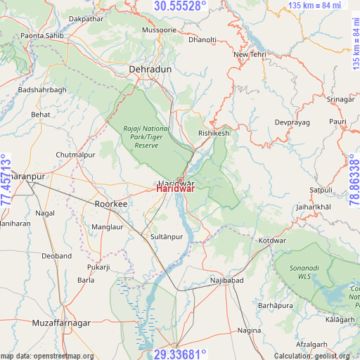
Haridwar GPS coordinates[2]
29° 56' 52.476" North, 78° 9' 36.9" East
| Map corner | latitude | longitude |
|---|---|---|
| Upper-left | 30.55528°, | 77.45713° |
| Center: | 29.94791°, | 78.16025° |
| Lower-right: | 29.33681°, | 78.86338° |
| Map W x H: | 135.5×135.5 km | = 84.2×84.2mi |
| max Lat: | 34.9274° ⇑7.4% North |
| Haridwar: | 29.94791° |
| min Lat: | ⇓92.6% South 8.09008° |
| min Long | Haridwar | max Long |
| 68.82655° | 78.16025° | 96.81° |
| W 50.8%⇐ | ⇒49.2% E |
Elevation
Elevation of Haridwar is 295 m = 968 ft, and this is 0.60000000000002 m = 2 ft below average elevation for this country.
| Max E: |
3681 m = 12077 ft | 33.8% |
| Avg. | 295.6 m = 970 ft | |
| Haridwar | 295 m = 968 ft | |
Min E: |
1 m = 3 ft | 66.2% |
See also: Haridwar elevation on elevation.city.
Geographical zone
Haridwar is located in North temperate zone (between Tropic of Cancer and the Arctic Circle). Distance of this Northern Tropic circle is 724 km =449.9 mi to South.| Distance of | km | miles | from Haridwar |
|---|---|---|---|
| North Pole | 6677.2 | 4149 | to North |
| Arctic Circle | 4071.3 | 2529.8 | to North |
| Tropic Cancer | 724 | 449.9 | to South |
| Equator | 3329.9 | 2069.1 | to South |


Nearby cities:
15 places around Haridwar: (largest is in red/bold)
• Birbhaddar
18 km =11.2 mi,  40°
40°
• Chhutmalpur
40.3 km =25 mi,  283°
283°
• Clement Town
38 km =23.6 mi,  337°
337°
• Dehra Dūn
43.6 km =27.1 mi, 343°
• Doiwāla
25.8 km =16 mi,  350°
350°
• Kotdwāra
41.5 km =25.8 mi,  122°
122°
• Laksar
24 km =14.9 mi,  208°
208°
• Manglaur
32.3 km =20.1 mi,  237°
237°
• Najībābād
41.3 km =25.7 mi,  154°
154°
• Narendranagar
26.7 km =16.6 mi,  27°
27°
• Rishīkesh
21.9 km =13.6 mi, 35°
• Roorkee
27.5 km =17.1 mi,  250°
250°
• Rāipur
40.9 km =25.4 mi, 350°
• Rāīwāla Bara
10.3 km =6.4 mi, 40°
• Sultānpur
21.9 km =13.6 mi,  192°
192°
Sources, notices
• [Note1] Compared only with cities in India existing in our database
• [Src1] Map data: © OpenStreetMap contributors (CC-BY-SA)
• [Src2] Other city data from geonames.org with taken over terms of usage.
• [Src3] Geographical zone / Annual Mean Temperature by Robert A. Rohde @ Wikipedia
