Rāipur geodata
Rāipur (Uttarakhand) is a populated place; located in India in Asia/Kolkata (GMT+5.5) time zone. With population of 27,702 people, there are 1557 cities with bigger population in this country. Compared to other cities in India, 93.8% of cities are located further ↓South; 50.4% of cities are located further →East and 91.9% of cities have lower elevation than Rāipur. Note1


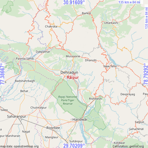
Rāipur GPS coordinates[2]
30° 18' 39.492" North, 78° 5' 23.244" East
| Map corner | latitude | longitude |
|---|---|---|
| Upper-left | 30.91609°, | 77.38667° |
| Center: | 30.31097°, | 78.08979° |
| Lower-right: | 29.70209°, | 78.79292° |
| Map W x H: | 135×135 km | = 83.9×83.9mi |
| max Lat: | 34.9274° ⇑6.2% North |
| Rāipur: | 30.31097° |
| min Lat: | ⇓93.8% South 8.09008° |
| min Long | Rāipur | max Long |
| 68.82655° | 78.08979° | 96.81° |
| W 49.6%⇐ | ⇒50.4% E |
Elevation
Elevation of Rāipur is 680 m = 2231 ft, and this is 384.4 m = 1261 ft above average elevation for this country.
| Max E: |
3681 m = 12077 ft | 8.1% |
| Rāipur | 680 m 2231 ft | |
| Avg. | 295.6 m = 970 ft | |
Min E: |
1 m = 3 ft | 91.9% |
See also: India elevation on elevation.city.
Geographical zone
Rāipur is located in North temperate zone (between Tropic of Cancer and the Arctic Circle). Distance of this Northern Tropic circle is 764.3 km =474.9 mi to South.| Distance of | km | miles | from Rāipur |
|---|---|---|---|
| North Pole | 6636.8 | 4123.9 | to North |
| Arctic Circle | 4030.9 | 2504.7 | to North |
| Tropic Cancer | 764.3 | 474.9 | to South |
| Equator | 3370.3 | 2094.2 | to South |


Nearby cities:
15 places around Rāipur: (largest is in red/bold)
• Behat
48.3 km =30 mi,  251°
251°
• Birbhaddar
32.4 km =20.1 mi,  145°
145°
• Chhutmalpur
44.8 km =27.8 mi,  226°
226°
• Clement Town
9.4 km =5.8 mi,  235°
235°
• Dehra Dūn
5.6 km =3.5 mi,  285°
285°
• Doiwāla
15.2 km =9.4 mi,  170°
170°
• Harbatpur
36.4 km =22.6 mi, 292°
• Haridwar
40.9 km =25.4 mi, 170°
• Mussoorie
16.1 km =10 mi,  353°
353°
• Narendranagar
25.2 km =15.7 mi,  131°
131°
• Pāonta Sāhib
46.8 km =29.1 mi, 287°
• Rishīkesh
29.8 km =18.5 mi,  139°
139°
• Rāīwāla Bara
35.2 km =21.9 mi,  157°
157°
• Tehri
38.5 km =23.9 mi,  76°
76°
• Vikāsnagar
35.1 km =21.8 mi,  300°
300°
Sources, notices
• [Note1] Compared only with cities in India existing in our database
• [Src1] Map data: © OpenStreetMap contributors (CC-BY-SA)
• [Src2] Other city data from geonames.org with taken over terms of usage.
• [Src3] Geographical zone / Annual Mean Temperature by Robert A. Rohde @ Wikipedia
