Dugadda geodata
Dugadda (Uttarakhand) is a populated place; located in India in Asia/Kolkata (GMT+5.5) time zone. With population of 2,780 people, there are 3419 cities with bigger population in this country. Compared to other cities in India, 92.3% of cities are located further ↓South; 55.3% of cities are located further ←West and 93.2% of cities have lower elevation than Dugadda. Note1


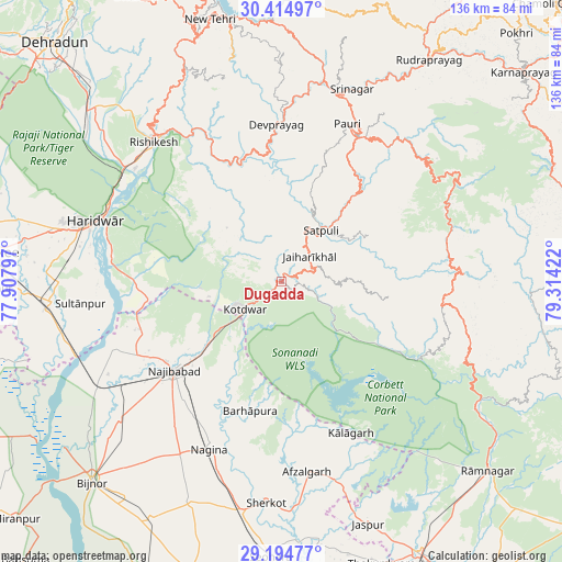
Dugadda GPS coordinates[2]
29° 48' 24.228" North, 78° 36' 39.924" East
| Map corner | latitude | longitude |
|---|---|---|
| Upper-left | 30.41497°, | 77.90797° |
| Center: | 29.80673°, | 78.61109° |
| Lower-right: | 29.19477°, | 79.31422° |
| Map W x H: | 135.7×135.7 km | = 84.3×84.3mi |
| max Lat: | 34.9274° ⇑7.7% North |
| Dugadda: | 29.80673° |
| min Lat: | ⇓92.3% South 8.09008° |
| min Long | Dugadda | max Long |
| 68.82655° | 78.61109° | 96.81° |
| W 55.3%⇐ | ⇒44.7% E |
Elevation
Elevation of Dugadda is 763 m = 2503 ft, and this is 467.4 m = 1533 ft above average elevation for this country.
| Max E: |
3681 m = 12077 ft | 6.8% |
| Dugadda | 763 m 2503 ft | |
| Avg. | 295.6 m = 970 ft | |
Min E: |
1 m = 3 ft | 93.2% |
See also: India elevation on elevation.city.
Geographical zone
Dugadda is located in North temperate zone (between Tropic of Cancer and the Arctic Circle). Distance of this Northern Tropic circle is 708.3 km =440.1 mi to South.| Distance of | km | miles | from Dugadda |
|---|---|---|---|
| North Pole | 6692.9 | 4158.8 | to North |
| Arctic Circle | 4087 | 2539.5 | to North |
| Tropic Cancer | 708.3 | 440.1 | to South |
| Equator | 3314.2 | 2059.3 | to South |


Nearby cities:
15 places around Dugadda: (largest is in red/bold)
• Afzalgarh
46.3 km =28.8 mi,  172°
172°
• Birbhaddar
43.3 km =26.9 mi,  312°
312°
• Devaprayāg
37.7 km =23.4 mi,  358°
358°
• Haridwar
46.2 km =28.7 mi,  289°
289°
• Kotdwāra
10.9 km =6.8 mi,  231°
231°
• Kālāgarh Project Colony
40.2 km =25 mi,  155°
155°
• Lansdowne
7.7 km =4.8 mi,  59°
59°
• Nagīna
43.7 km =27.2 mi,  202°
202°
• Najībābād
33.8 km =21 mi, 230°
• Narendranagar
50.3 km =31.3 mi,  321°
321°
• Pauri
41.7 km =25.9 mi,  22°
22°
• Rishīkesh
45.4 km =28.2 mi, 317°
• Rāīwāla Bara
43.7 km =27.2 mi,  302°
302°
• Srīnagar
49.1 km =30.5 mi, 19°
• Sultānpur
48.7 km =30.3 mi,  263°
263°
Sources, notices
• [Note1] Compared only with cities in India existing in our database
• [Src1] Map data: © OpenStreetMap contributors (CC-BY-SA)
• [Src2] Other city data from geonames.org with taken over terms of usage.
• [Src3] Geographical zone / Annual Mean Temperature by Robert A. Rohde @ Wikipedia
