Clement Town geodata
Clement Town (Uttarakhand) is a populated place; located in India in Asia/Kolkata (GMT+5.5) time zone. With population of 20,806 people, there are 1981 cities with bigger population in this country. Compared to other cities in India, 93.6% of cities are located further ↓South; 51.3% of cities are located further →East and 88.7% of cities have lower elevation than Clement Town. Note1


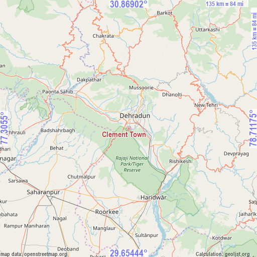
Clement Town GPS coordinates[2]
30° 15' 48.996" North, 78° 0' 31.032" East
| Map corner | latitude | longitude |
|---|---|---|
| Upper-left | 30.86902°, | 77.3055° |
| Center: | 30.26361°, | 78.00862° |
| Lower-right: | 29.65444°, | 78.71175° |
| Map W x H: | 135×135.1 km | = 83.9×83.9mi |
| max Lat: | 34.9274° ⇑6.4% North |
| Clement Town: | 30.26361° |
| min Lat: | ⇓93.6% South 8.09008° |
| min Long | Clement Town | max Long |
| 68.82655° | 78.00862° | 96.81° |
| W 48.7%⇐ | ⇒51.3% E |
Elevation
Elevation of Clement Town is 607 m = 1991 ft, and this is 311.4 m = 1022 ft above average elevation for this country.
| Max E: |
3681 m = 12077 ft | 11.3% |
| Clement Town | 607 m 1991 ft | |
| Avg. | 295.6 m = 970 ft | |
Min E: |
1 m = 3 ft | 88.7% |
See also: India elevation on elevation.city.
Geographical zone
Clement Town is located in North temperate zone (between Tropic of Cancer and the Arctic Circle). Distance of this Northern Tropic circle is 759.1 km =471.7 mi to South.| Distance of | km | miles | from Clement Town |
|---|---|---|---|
| North Pole | 6642.1 | 4127.2 | to North |
| Arctic Circle | 4036.2 | 2508 | to North |
| Tropic Cancer | 759.1 | 471.7 | to South |
| Equator | 3365 | 2090.9 | to South |


Nearby cities:
15 places around Clement Town: (largest is in red/bold)
• Behat
39.3 km =24.4 mi,  254°
254°
• Birbhaddar
33.9 km =21.1 mi,  129°
129°
• Chhutmalpur
35.6 km =22.1 mi,  223°
223°
• Dehra Dūn
7.2 km =4.5 mi,  19°
19°
• Doiwāla
14.2 km =8.8 mi, 132°
• Harbatpur
32.3 km =20.1 mi,  307°
307°
• Haridwar
38 km =23.6 mi,  157°
157°
• Mussoorie
22.1 km =13.7 mi, 15°
• Narendranagar
29.1 km =18.1 mi,  112°
112°
• Pāonta Sāhib
41.6 km =25.8 mi,  297°
297°
• Rishīkesh
32.3 km =20.1 mi,  122°
122°
• Roorkee
45.6 km =28.3 mi,  194°
194°
• Rāipur
9.4 km =5.8 mi,  55°
55°
• Rāīwāla Bara
34.5 km =21.4 mi,  142°
142°
• Vikāsnagar
32.2 km =20 mi,  315°
315°
Sources, notices
• [Note1] Compared only with cities in India existing in our database
• [Src1] Map data: © OpenStreetMap contributors (CC-BY-SA)
• [Src2] Other city data from geonames.org with taken over terms of usage.
• [Src3] Geographical zone / Annual Mean Temperature by Robert A. Rohde @ Wikipedia
