Rāichūr geodata
Rāichūr (Karnataka) is a populated place; located in India in Asia/Kolkata (GMT+5.5) time zone. With population of 225,962 people, there are 188 cities with bigger population in this country. Compared to other cities in India, 77.4% of cities are located further ↑North; 58.9% of cities are located further →East and 76.2% of cities have lower elevation than Rāichūr. Note1


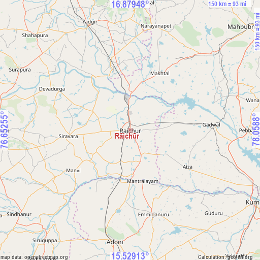
Rāichūr GPS coordinates[2]
16° 12' 19.656" North, 77° 21' 20.412" East
| Map corner | latitude | longitude |
|---|---|---|
| Upper-left | 16.87948°, | 76.65255° |
| Center: | 16.20546°, | 77.35567° |
| Lower-right: | 15.52913°, | 78.0588° |
| Map W x H: | 150.1×150.1 km | = 93.3×93.3mi |
| max Lat: | 34.9274° ⇑77.4% North |
| Rāichūr: | 16.20546° |
| min Lat: | ⇓22.6% South 8.09008° |
| min Long | Rāichūr | max Long |
| 68.82655° | 77.35567° | 96.81° |
| W 41.1%⇐ | ⇒58.9% E |
Elevation
Elevation of Rāichūr is 402 m = 1319 ft, and this is 106.4 m = 349 ft above average elevation for this country.
| Max E: |
3681 m = 12077 ft | 23.8% |
| Rāichūr | 402 m 1319 ft | |
| Avg. | 295.6 m = 970 ft | |
Min E: |
1 m = 3 ft | 76.2% |
See also: Rāichūr elevation on elevation.city.
Geographical zone
Rāichūr is located in North Torrid zone (between Equator and Tropic of Cancer). Distance of this Northern Tropic circle is 804 km =499.6 mi to North.| Distance of | km | miles | from Rāichūr |
|---|---|---|---|
| North Pole | 8205.2 | 5098.5 | to North |
| Arctic Circle | 5599.3 | 3479.2 | to North |
| Tropic Cancer | 804 | 499.6 | to North |
| Equator | 1801.9 | 1119.6 | to South |


Nearby cities:
15 places around Rāichūr: (largest is in red/bold)
• Emmiganūr
50.1 km =31.1 mi,  164°
164°
• Gadwāl
47.1 km =29.3 mi,  85°
85°
• Gopālur
66.1 km =41.1 mi,  46°
46°
• Gurmatkāl
73.7 km =45.8 mi,  2°
2°
• Kosigi
40.7 km =25.3 mi,  196°
196°
• Kurnool
83.9 km =52.1 mi,  119°
119°
• Mānvi
40.4 km =25.1 mi,  233°
233°
• Nārāyanpet
62.1 km =38.6 mi,  13°
13°
• Shorāpur
72.8 km =45.2 mi,  298°
298°
• Shāhpur
77.3 km =48 mi,  314°
314°
• Sindhnūr
80.4 km =50 mi, 232°
• Siruguppa
80.9 km =50.3 mi,  217°
217°
• Wanparti
78.2 km =48.6 mi,  76°
76°
• Yādgīr
66.9 km =41.6 mi,  339°
339°
• Ādoni
64.8 km =40.3 mi,  187°
187°
Sources, notices
• [Note1] Compared only with cities in India existing in our database
• [Src1] Map data: © OpenStreetMap contributors (CC-BY-SA)
• [Src2] Other city data from geonames.org with taken over terms of usage.
• [Src3] Geographical zone / Annual Mean Temperature by Robert A. Rohde @ Wikipedia
