Shāhpur geodata
Shāhpur (Karnataka) is a populated place; located in India in Asia/Kolkata (GMT+5.5) time zone. With population of 31,422 people, there are 1378 cities with bigger population in this country. Compared to other cities in India, 75.7% of cities are located further ↑North; 64.8% of cities are located further →East and 77.2% of cities have lower elevation than Shāhpur. Note1


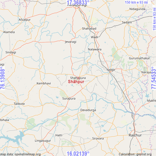
Shāhpur GPS coordinates[2]
16° 41' 45.78" North, 76° 50' 31.92" East
| Map corner | latitude | longitude |
|---|---|---|
| Upper-left | 17.36833°, | 76.13908° |
| Center: | 16.69605°, | 76.8422° |
| Lower-right: | 16.02139°, | 77.54533° |
| Map W x H: | 149.8×149.8 km | = 93.1×93.1mi |
| max Lat: | 34.9274° ⇑75.7% North |
| Shāhpur: | 16.69605° |
| min Lat: | ⇓24.3% South 8.09008° |
| min Long | Shāhpur | max Long |
| 68.82655° | 76.8422° | 96.81° |
| W 35.2%⇐ | ⇒64.8% E |
Elevation
Elevation of Shāhpur is 418 m = 1371 ft, and this is 122.4 m = 402 ft above average elevation for this country.
| Max E: |
3681 m = 12077 ft | 22.8% |
| Shāhpur | 418 m 1371 ft | |
| Avg. | 295.6 m = 970 ft | |
Min E: |
1 m = 3 ft | 77.2% |
See also: India elevation on elevation.city.
Geographical zone
Shāhpur is located in North Torrid zone (between Equator and Tropic of Cancer). Distance of this Northern Tropic circle is 749.5 km =465.7 mi to North.| Distance of | km | miles | from Shāhpur |
|---|---|---|---|
| North Pole | 8150.6 | 5064.5 | to North |
| Arctic Circle | 5544.7 | 3445.3 | to North |
| Tropic Cancer | 749.5 | 465.7 | to North |
| Equator | 1856.4 | 1153.5 | to South |


Nearby cities:
15 places around Shāhpur: (largest is in red/bold)
• Afzalpur
75.9 km =47.2 mi,  317°
317°
• Chītāpur
54 km =33.6 mi,  28°
28°
• Gulbarga
71.1 km =44.2 mi,  359°
359°
• Gurmatkāl
61.4 km =38.2 mi,  71°
71°
• Jevargi
36.1 km =22.4 mi,  348°
348°
• Lingsugūr
68.8 km =42.8 mi,  209°
209°
• Nārāyanpet
69.8 km =43.4 mi,  85°
85°
• Rāichūr
77.3 km =48 mi,  134°
134°
• Seram
71.7 km =44.6 mi,  41°
41°
• Shorāpur
21.5 km =13.4 mi,  204°
204°
• Shāhābād
49.5 km =30.8 mi,  12°
12°
• Sindgi
69.3 km =43.1 mi,  290°
290°
• Tālīkota
61.8 km =38.4 mi,  246°
246°
• Wādi
42.6 km =26.5 mi,  21°
21°
• Yādgīr
32.5 km =20.2 mi,  75°
75°
Sources, notices
• [Note1] Compared only with cities in India existing in our database
• [Src1] Map data: © OpenStreetMap contributors (CC-BY-SA)
• [Src2] Other city data from geonames.org with taken over terms of usage.
• [Src3] Geographical zone / Annual Mean Temperature by Robert A. Rohde @ Wikipedia
