Gopālur geodata
Gopālur (Telangana) is a populated place; located in India in Asia/Kolkata (GMT+5.5) time zone. With population of 3,324 people, there are 3401 cities with bigger population in this country. Compared to other cities in India, 76% of cities are located further ↑North; 53.5% of cities are located further →East and 74.6% of cities have lower elevation than Gopālur. Note1


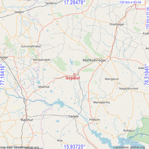
Gopālur GPS coordinates[2]
16° 36' 43.92" North, 77° 48' 26.208" East
| Map corner | latitude | longitude |
|---|---|---|
| Upper-left | 17.28478°, | 77.10416° |
| Center: | 16.6122°, | 77.80728° |
| Lower-right: | 15.93725°, | 78.51041° |
| Map W x H: | 149.8×149.8 km | = 93.1×93.1mi |
| max Lat: | 34.9274° ⇑76% North |
| Gopālur: | 16.6122° |
| min Lat: | ⇓24% South 8.09008° |
| min Long | Gopālur | max Long |
| 68.82655° | 77.80728° | 96.81° |
| W 46.5%⇐ | ⇒53.5% E |
Elevation
Elevation of Gopālur is 381 m = 1250 ft, and this is 85.4 m = 280 ft above average elevation for this country.
| Max E: |
3681 m = 12077 ft | 25.4% |
| Gopālur | 381 m 1250 ft | |
| Avg. | 295.6 m = 970 ft | |
Min E: |
1 m = 3 ft | 74.6% |
See also: India elevation on elevation.city.
Geographical zone
Gopālur is located in North Torrid zone (between Equator and Tropic of Cancer). Distance of this Northern Tropic circle is 758.8 km =471.5 mi to North.| Distance of | km | miles | from Gopālur |
|---|---|---|---|
| North Pole | 8160 | 5070.4 | to North |
| Arctic Circle | 5554.1 | 3451.2 | to North |
| Tropic Cancer | 758.8 | 471.5 | to North |
| Equator | 1847.1 | 1147.7 | to South |


Nearby cities:
15 places around Gopālur: (largest is in red/bold)
• Farrukhnagar
66.8 km =41.5 mi,  39°
39°
• Gadwāl
42 km =26.1 mi,  181°
181°
• Gurmatkāl
52.7 km =32.7 mi,  302°
302°
• Kurgunta
80.4 km =50 mi,  323°
323°
• Mahbūbnagar
24 km =14.9 mi,  52°
52°
• Nāgar Karnūl
57 km =35.4 mi,  104°
104°
• Nārāyanpet
36.5 km =22.7 mi,  294°
294°
• Rāichūr
66.1 km =41.1 mi,  226°
226°
• Seram
83.6 km =51.9 mi, 318°
• Srīrāmnagar
87 km =54.1 mi,  33°
33°
• Tāndūr
74.9 km =46.5 mi,  340°
340°
• Vikārābād
81.4 km =50.6 mi,  7°
7°
• Wanparti
39 km =24.2 mi,  134°
134°
• Yādgīr
73.5 km =45.7 mi,  283°
283°
• Ālampur
88.6 km =55.1 mi,  156°
156°
Sources, notices
• [Note1] Compared only with cities in India existing in our database
• [Src1] Map data: © OpenStreetMap contributors (CC-BY-SA)
• [Src2] Other city data from geonames.org with taken over terms of usage.
• [Src3] Geographical zone / Annual Mean Temperature by Robert A. Rohde @ Wikipedia
