Shorāpur geodata
Shorāpur (Karnataka) is a populated place; located in India in Asia/Kolkata (GMT+5.5) time zone. With population of 49,501 people, there are 897 cities with bigger population in this country. Compared to other cities in India, 76.3% of cities are located further ↑North; 65.6% of cities are located further →East and 81.5% of cities have lower elevation than Shorāpur. Note1


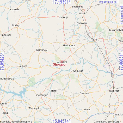
Shorāpur GPS coordinates[2]
16° 31' 15.6" North, 76° 45' 26.568" East
| Map corner | latitude | longitude |
|---|---|---|
| Upper-left | 17.19391°, | 76.05426° |
| Center: | 16.521°, | 76.75738° |
| Lower-right: | 15.84574°, | 77.46051° |
| Map W x H: | 149.9×149.9 km | = 93.1×93.1mi |
| max Lat: | 34.9274° ⇑76.3% North |
| Shorāpur: | 16.521° |
| min Lat: | ⇓23.7% South 8.09008° |
| min Long | Shorāpur | max Long |
| 68.82655° | 76.75738° | 96.81° |
| W 34.4%⇐ | ⇒65.6% E |
Elevation
Elevation of Shorāpur is 480 m = 1575 ft, and this is 184.4 m = 605 ft above average elevation for this country.
| Max E: |
3681 m = 12077 ft | 18.5% |
| Shorāpur | 480 m 1575 ft | |
| Avg. | 295.6 m = 970 ft | |
Min E: |
1 m = 3 ft | 81.5% |
See also: Shorāpur elevation on elevation.city.
Geographical zone
Shorāpur is located in North Torrid zone (between Equator and Tropic of Cancer). Distance of this Northern Tropic circle is 769 km =477.8 mi to North.| Distance of | km | miles | from Shorāpur |
|---|---|---|---|
| North Pole | 8170.1 | 5076.7 | to North |
| Arctic Circle | 5564.2 | 3457.4 | to North |
| Tropic Cancer | 769 | 477.8 | to North |
| Equator | 1837 | 1141.5 | to South |


Nearby cities:
15 places around Shorāpur: (largest is in red/bold)
• Chītāpur
75.4 km =46.9 mi,  27°
27°
• Gurmatkāl
77.7 km =48.3 mi,  60°
60°
• Jevargi
54.8 km =34.1 mi,  1°
1°
• Lingsugūr
47.5 km =29.5 mi,  211°
211°
• Muddebihāl
69.8 km =43.4 mi,  253°
253°
• Mudgal
65.9 km =40.9 mi, 210°
• Mānvi
66.7 km =41.4 mi,  152°
152°
• Nārāyanpet
82.6 km =51.3 mi,  72°
72°
• Rāichūr
72.8 km =45.2 mi,  118°
118°
• Shāhpur
21.5 km =13.4 mi,  24°
24°
• Shāhābād
70.6 km =43.9 mi, 16°
• Sindgi
71.2 km =44.2 mi,  308°
308°
• Tālīkota
47.9 km =29.8 mi,  263°
263°
• Wādi
64 km =39.8 mi, 22°
• Yādgīr
49.1 km =30.5 mi, 55°
Sources, notices
• [Note1] Compared only with cities in India existing in our database
• [Src1] Map data: © OpenStreetMap contributors (CC-BY-SA)
• [Src2] Other city data from geonames.org with taken over terms of usage.
• [Src3] Geographical zone / Annual Mean Temperature by Robert A. Rohde @ Wikipedia
