Nārāyanpet geodata
Nārāyanpet (Telangana) is a populated place; located in India in Asia/Kolkata (GMT+5.5) time zone. With population of 39,041 people, there are 1132 cities with bigger population in this country. Compared to other cities in India, 75.5% of cities are located further ↑North; 57.3% of cities are located further →East and 78.8% of cities have lower elevation than Nārāyanpet. Note1


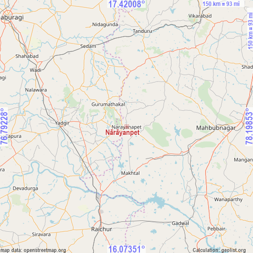
Nārāyanpet GPS coordinates[2]
16° 44' 52.764" North, 77° 29' 43.44" East
| Map corner | latitude | longitude |
|---|---|---|
| Upper-left | 17.42008°, | 76.79228° |
| Center: | 16.74799°, | 77.4954° |
| Lower-right: | 16.07351°, | 78.19853° |
| Map W x H: | 149.7×149.7 km | = 93×93mi |
| max Lat: | 34.9274° ⇑75.5% North |
| Nārāyanpet: | 16.74799° |
| min Lat: | ⇓24.5% South 8.09008° |
| min Long | Nārāyanpet | max Long |
| 68.82655° | 77.4954° | 96.81° |
| W 42.7%⇐ | ⇒57.3% E |
Elevation
Elevation of Nārāyanpet is 443 m = 1453 ft, and this is 147.4 m = 484 ft above average elevation for this country.
| Max E: |
3681 m = 12077 ft | 21.2% |
| Nārāyanpet | 443 m 1453 ft | |
| Avg. | 295.6 m = 970 ft | |
Min E: |
1 m = 3 ft | 78.8% |
See also: India elevation on elevation.city.
Geographical zone
Nārāyanpet is located in North Torrid zone (between Equator and Tropic of Cancer). Distance of this Northern Tropic circle is 743.7 km =462.1 mi to North.| Distance of | km | miles | from Nārāyanpet |
|---|---|---|---|
| North Pole | 8144.9 | 5061 | to North |
| Arctic Circle | 5539 | 3441.8 | to North |
| Tropic Cancer | 743.7 | 462.1 | to North |
| Equator | 1862.2 | 1157.1 | to South |


Nearby cities:
15 places around Nārāyanpet: (largest is in red/bold)
• Chītāpur
60.6 km =37.7 mi,  313°
313°
• Gadwāl
65.4 km =40.6 mi,  150°
150°
• Gopālur
36.5 km =22.7 mi,  114°
114°
• Gurmatkāl
17.4 km =10.8 mi,  320°
320°
• Kurgunta
51.6 km =32.1 mi,  343°
343°
• Mahbūbnagar
52.2 km =32.4 mi,  90°
90°
• Rāichūr
62.1 km =38.6 mi,  193°
193°
• Seram
52.6 km =32.7 mi, 335°
• Shāhpur
69.8 km =43.4 mi,  265°
265°
• Shāhābād
72.5 km =45 mi, 305°
• Tāndūr
56.3 km =35 mi,  8°
8°
• Vikārābād
78.7 km =48.9 mi,  33°
33°
• Wanparti
74.3 km =46.2 mi,  124°
124°
• Wādi
63.5 km =39.5 mi,  302°
302°
• Yādgīr
38.2 km =23.7 mi, 273°
Sources, notices
• [Note1] Compared only with cities in India existing in our database
• [Src1] Map data: © OpenStreetMap contributors (CC-BY-SA)
• [Src2] Other city data from geonames.org with taken over terms of usage.
• [Src3] Geographical zone / Annual Mean Temperature by Robert A. Rohde @ Wikipedia
