Gurmatkāl geodata
Gurmatkāl (Karnataka) is a populated place; located in India in Asia/Kolkata (GMT+5.5) time zone. With population of 18,236 people, there are 2185 cities with bigger population in this country. Compared to other cities in India, 75.2% of cities are located further ↑North; 58.4% of cities are located further →East and 88.2% of cities have lower elevation than Gurmatkāl. Note1


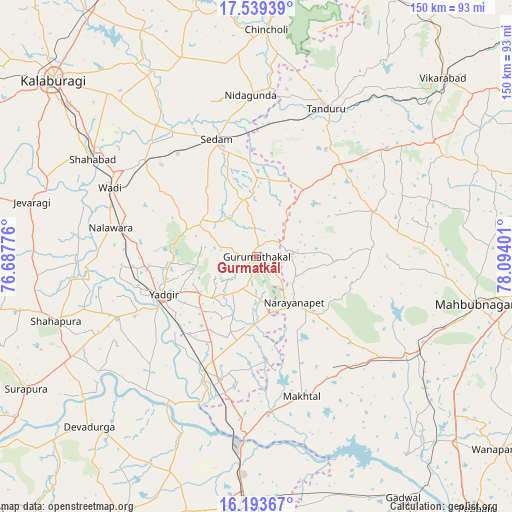
Gurmatkāl GPS coordinates[2]
16° 52' 3.828" North, 77° 23' 27.168" East
| Map corner | latitude | longitude |
|---|---|---|
| Upper-left | 17.53939°, | 76.68776° |
| Center: | 16.86773°, | 77.39088° |
| Lower-right: | 16.19367°, | 78.09401° |
| Map W x H: | 149.6×149.6 km | = 93×93mi |
| max Lat: | 34.9274° ⇑75.2% North |
| Gurmatkāl: | 16.86773° |
| min Lat: | ⇓24.8% South 8.09008° |
| min Long | Gurmatkāl | max Long |
| 68.82655° | 77.39088° | 96.81° |
| W 41.6%⇐ | ⇒58.4% E |
Elevation
Elevation of Gurmatkāl is 594 m = 1949 ft, and this is 298.4 m = 979 ft above average elevation for this country.
| Max E: |
3681 m = 12077 ft | 11.8% |
| Gurmatkāl | 594 m 1949 ft | |
| Avg. | 295.6 m = 970 ft | |
Min E: |
1 m = 3 ft | 88.2% |
See also: India elevation on elevation.city.
Geographical zone
Gurmatkāl is located in North Torrid zone (between Equator and Tropic of Cancer). Distance of this Northern Tropic circle is 730.4 km =453.8 mi to North.| Distance of | km | miles | from Gurmatkāl |
|---|---|---|---|
| North Pole | 8131.5 | 5052.7 | to North |
| Arctic Circle | 5525.7 | 3433.5 | to North |
| Tropic Cancer | 730.4 | 453.8 | to North |
| Equator | 1875.5 | 1165.4 | to South |


Nearby cities:
15 places around Gurmatkāl: (largest is in red/bold)
• Chincholi
66.5 km =41.3 mi,  2°
2°
• Chītāpur
43.4 km =27 mi,  310°
310°
• Gopālur
52.7 km =32.7 mi,  122°
122°
• Jevargi
67.7 km =42.1 mi,  283°
283°
• Kurgunta
36.4 km =22.6 mi,  354°
354°
• Mahbūbnagar
64.8 km =40.3 mi,  102°
102°
• Nārāyanpet
17.4 km =10.8 mi,  140°
140°
• Rāichūr
73.7 km =45.8 mi,  182°
182°
• Seram
36.2 km =22.5 mi,  342°
342°
• Shāhpur
61.4 km =38.2 mi,  251°
251°
• Shāhābād
55.8 km =34.7 mi,  301°
301°
• Tāndūr
46.7 km =29 mi,  25°
25°
• Vikārābād
75.6 km =47 mi,  46°
46°
• Wādi
47.2 km =29.3 mi, 295°
• Yādgīr
29.1 km =18.1 mi, 248°
Sources, notices
• [Note1] Compared only with cities in India existing in our database
• [Src1] Map data: © OpenStreetMap contributors (CC-BY-SA)
• [Src2] Other city data from geonames.org with taken over terms of usage.
• [Src3] Geographical zone / Annual Mean Temperature by Robert A. Rohde @ Wikipedia
