Nūrpur Kalān geodata
Nūrpur Kalān (Punjab) is a populated place; located in India in Asia/Kolkata (GMT+5.5) time zone. With population of 9,437 people, there are 2999 cities with bigger population in this country. Compared to other cities in India, 96.3% of cities are located further ↓South; 68.7% of cities are located further →East and 66.6% of cities have lower elevation than Nūrpur Kalān. Note1


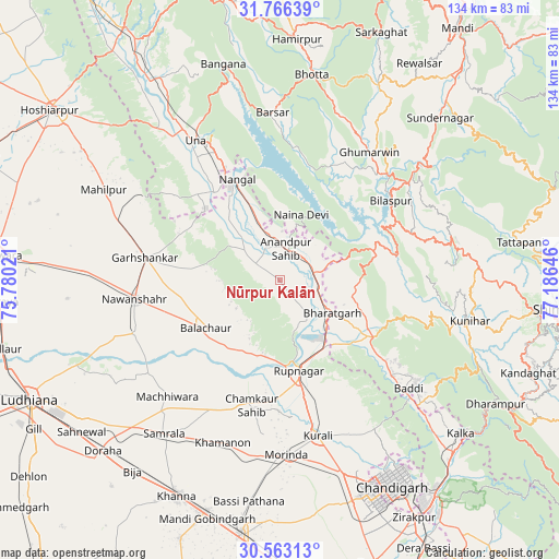
Nūrpur Kalān GPS coordinates[2]
31° 10' 0.012" North, 76° 28' 59.988" East
| Map corner | latitude | longitude |
|---|---|---|
| Upper-left | 31.76639°, | 75.78021° |
| Center: | 31.16667°, | 76.48333° |
| Lower-right: | 30.56313°, | 77.18646° |
| Map W x H: | 133.8×133.8 km | = 83.1×83.1mi |
| max Lat: | 34.9274° ⇑3.7% North |
| Nūrpur Kalān: | 31.16667° |
| min Lat: | ⇓96.3% South 8.09008° |
| min Long | Nūrpur Kalān | max Long |
| 68.82655° | 76.48333° | 96.81° |
| W 31.3%⇐ | ⇒68.7% E |
Elevation
Elevation of Nūrpur Kalān is 299 m = 981 ft, and this is 3.4 m = 11 ft above average elevation for this country.
| Max E: |
3681 m = 12077 ft | 33.4% |
| Nūrpur Kalān | 299 m 981 ft | |
| Avg. | 295.6 m = 970 ft | |
Min E: |
1 m = 3 ft | 66.6% |
See also: India elevation on elevation.city.
Geographical zone
Nūrpur Kalān is located in North temperate zone (between Tropic of Cancer and the Arctic Circle). Distance of this Northern Tropic circle is 859.5 km =534.1 mi to South.| Distance of | km | miles | from Nūrpur Kalān |
|---|---|---|---|
| North Pole | 6541.7 | 4064.8 | to North |
| Arctic Circle | 3935.8 | 2445.6 | to North |
| Tropic Cancer | 859.5 | 534.1 | to South |
| Equator | 3465.4 | 2153.3 | to South |


Nearby cities:
15 places around Nūrpur Kalān: (largest is in red/bold)
• Anandpur
8.3 km =5.2 mi,  12°
12°
• Baddi
37.4 km =23.2 mi,  128°
128°
• Bilaspur
31.7 km =19.7 mi,  55°
55°
• Bālāchor
20.9 km =13 mi,  235°
235°
• Garhshankar
33 km =20.5 mi,  279°
279°
• Ghumārwīn
37.7 km =23.4 mi,  35°
35°
• Khamānon Kalān
40.7 km =25.3 mi,  197°
197°
• Māchhīwāra
38.8 km =24.1 mi,  224°
224°
• Nangal
26.8 km =16.7 mi,  337°
337°
• Nawanshahr
35.3 km =21.9 mi,  262°
262°
• Nālāgarh
26.7 km =16.6 mi,  121°
121°
• Ropar
22.4 km =13.9 mi,  169°
169°
• Rāhon
36.9 km =22.9 mi,  249°
249°
• Santokhgarh
25.9 km =16.1 mi,  322°
322°
• Una
38.9 km =24.2 mi,  328°
328°
Sources, notices
• [Note1] Compared only with cities in India existing in our database
• [Src1] Map data: © OpenStreetMap contributors (CC-BY-SA)
• [Src2] Other city data from geonames.org with taken over terms of usage.
• [Src3] Geographical zone / Annual Mean Temperature by Robert A. Rohde @ Wikipedia
