Pushkar geodata
Pushkar (Rajasthan) is a populated place; located in India in Asia/Kolkata (GMT+5.5) time zone. With population of 16,173 people, there are 2359 cities with bigger population in this country. Compared to other cities in India, 74.6% of cities are located further ↓South; 86.5% of cities are located further →East and 82.2% of cities have lower elevation than Pushkar. Note1


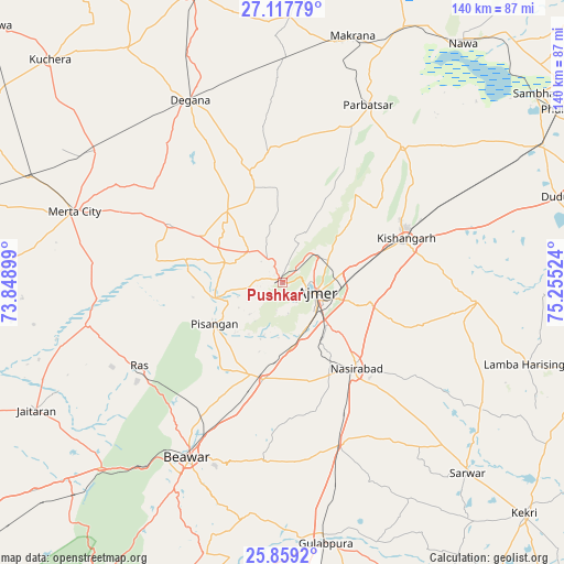
Pushkar GPS coordinates[2]
26° 29' 24.792" North, 74° 33' 7.596" East
| Map corner | latitude | longitude |
|---|---|---|
| Upper-left | 27.11779°, | 73.84899° |
| Center: | 26.49022°, | 74.55211° |
| Lower-right: | 25.8592°, | 75.25524° |
| Map W x H: | 139.9×139.9 km | = 86.9×86.9mi |
| max Lat: | 34.9274° ⇑25.4% North |
| Pushkar: | 26.49022° |
| min Lat: | ⇓74.6% South 8.09008° |
| min Long | Pushkar | max Long |
| 68.82655° | 74.55211° | 96.81° |
| W 13.5%⇐ | ⇒86.5% E |
Elevation
Elevation of Pushkar is 495 m = 1624 ft, and this is 199.4 m = 654 ft above average elevation for this country.
| Max E: |
3681 m = 12077 ft | 17.8% |
| Pushkar | 495 m 1624 ft | |
| Avg. | 295.6 m = 970 ft | |
Min E: |
1 m = 3 ft | 82.2% |
See also: India elevation on elevation.city.
Geographical zone
Pushkar is located in North temperate zone (between Tropic of Cancer and the Arctic Circle). Distance of this Northern Tropic circle is 339.5 km =211 mi to South.| Distance of | km | miles | from Pushkar |
|---|---|---|---|
| North Pole | 7061.6 | 4387.9 | to North |
| Arctic Circle | 4455.7 | 2768.6 | to North |
| Tropic Cancer | 339.5 | 211 | to South |
| Equator | 2945.4 | 1830.2 | to South |


Nearby cities:
15 places around Pushkar: (largest is in red/bold)
• Ajmer
9.6 km =6 mi,  116°
116°
• Beāwar
49 km =30.4 mi,  208°
208°
• Gulābpura
66 km =41 mi,  170°
170°
• Jaitāran
69.1 km =42.9 mi,  242°
242°
• Kishangarh
32 km =19.9 mi,  69°
69°
• Makrāna
63.9 km =39.7 mi,  15°
15°
• Merta
54.4 km =33.8 mi,  288°
288°
• Naraina
73.1 km =45.4 mi,  62°
62°
• Nasīrābād
27.4 km =17 mi,  138°
138°
• Nāwa
73.9 km =45.9 mi,  37°
37°
• Nīmāj
66.7 km =41.4 mi, 235°
• Parvatsar
48.9 km =30.4 mi,  25°
25°
• Raipur
72.5 km =45 mi,  226°
226°
• Sarwār
66 km =41 mi, 136°
• Uniāra
76 km =47.2 mi, 119°
Sources, notices
• [Note1] Compared only with cities in India existing in our database
• [Src1] Map data: © OpenStreetMap contributors (CC-BY-SA)
• [Src2] Other city data from geonames.org with taken over terms of usage.
• [Src3] Geographical zone / Annual Mean Temperature by Robert A. Rohde @ Wikipedia
