Ajmer geodata
Ajmer (Rajasthan) is a populated place; located in India in Asia/Kolkata (GMT+5.5) time zone. With population of 517,911 people, there are 84 cities with bigger population in this country. Compared to other cities in India, 74.1% of cities are located further ↓South; 85.7% of cities are located further →East and 81.3% of cities have lower elevation than Ajmer. Note1


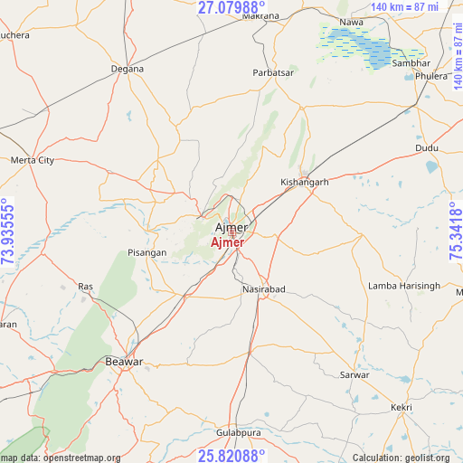
Ajmer GPS coordinates[2]
26° 27' 7.56" North, 74° 38' 19.212" East
| Map corner | latitude | longitude |
|---|---|---|
| Upper-left | 27.07988°, | 73.93555° |
| Center: | 26.4521°, | 74.63867° |
| Lower-right: | 25.82088°, | 75.3418° |
| Map W x H: | 140×140 km | = 87×87mi |
| max Lat: | 34.9274° ⇑25.9% North |
| Ajmer: | 26.4521° |
| min Lat: | ⇓74.1% South 8.09008° |
| min Long | Ajmer | max Long |
| 68.82655° | 74.63867° | 96.81° |
| W 14.3%⇐ | ⇒85.7% E |
Elevation
Elevation of Ajmer is 475 m = 1558 ft, and this is 179.4 m = 589 ft above average elevation for this country.
| Max E: |
3681 m = 12077 ft | 18.7% |
| Ajmer | 475 m 1558 ft | |
| Avg. | 295.6 m = 970 ft | |
Min E: |
1 m = 3 ft | 81.3% |
See also: Ajmer elevation on elevation.city.
Geographical zone
Ajmer is located in North temperate zone (between Tropic of Cancer and the Arctic Circle). Distance of this Northern Tropic circle is 335.3 km =208.3 mi to South.| Distance of | km | miles | from Ajmer |
|---|---|---|---|
| North Pole | 7065.9 | 4390.5 | to North |
| Arctic Circle | 4460 | 2771.3 | to North |
| Tropic Cancer | 335.3 | 208.3 | to South |
| Equator | 2941.2 | 1827.6 | to South |


Nearby cities:
15 places around Ajmer: (largest is in red/bold)
• Beāwar
50.3 km =31.3 mi,  219°
219°
• Gulābpura
60.9 km =37.8 mi,  177°
177°
• Kekri
73.9 km =45.9 mi,  136°
136°
• Kishangarh
26.3 km =16.3 mi,  54°
54°
• Makrāna
66.3 km =41.2 mi,  7°
7°
• Merta
64 km =39.8 mi,  289°
289°
• Naraina
67.8 km =42.1 mi,  56°
56°
• Nasīrābād
18.9 km =11.7 mi,  150°
150°
• Nāwa
72.7 km =45.2 mi,  29°
29°
• Nīmāj
71.9 km =44.7 mi,  242°
242°
• Parvatsar
49.9 km =31 mi, 14°
• Pushkar
9.6 km =6 mi,  296°
296°
• Sarwār
57 km =35.4 mi, 139°
• Sāmbhar
74.7 km =46.4 mi, 47°
• Uniāra
66.4 km =41.3 mi,  120°
120°
Sources, notices
• [Note1] Compared only with cities in India existing in our database
• [Src1] Map data: © OpenStreetMap contributors (CC-BY-SA)
• [Src2] Other city data from geonames.org with taken over terms of usage.
• [Src3] Geographical zone / Annual Mean Temperature by Robert A. Rohde @ Wikipedia
