Nasīrābād geodata
Nasīrābād (Rajasthan) is a populated place; located in India in Asia/Kolkata (GMT+5.5) time zone. With population of 51,747 people, there are 864 cities with bigger population in this country. Compared to other cities in India, 73% of cities are located further ↓South; 85% of cities are located further →East and 78.3% of cities have lower elevation than Nasīrābād. Note1


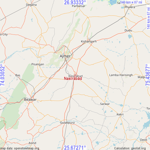
Nasīrābād GPS coordinates[2]
26° 18' 17.028" North, 74° 44' 1.104" East
| Map corner | latitude | longitude |
|---|---|---|
| Upper-left | 26.93332°, | 74.03052° |
| Center: | 26.30473°, | 74.73364° |
| Lower-right: | 25.67271°, | 75.43677° |
| Map W x H: | 140.2×140.2 km | = 87.1×87.1mi |
| max Lat: | 34.9274° ⇑27% North |
| Nasīrābād: | 26.30473° |
| min Lat: | ⇓73% South 8.09008° |
| min Long | Nasīrābād | max Long |
| 68.82655° | 74.73364° | 96.81° |
| W 15%⇐ | ⇒85% E |
Elevation
Elevation of Nasīrābād is 435 m = 1427 ft, and this is 139.4 m = 457 ft above average elevation for this country.
| Max E: |
3681 m = 12077 ft | 21.7% |
| Nasīrābād | 435 m 1427 ft | |
| Avg. | 295.6 m = 970 ft | |
Min E: |
1 m = 3 ft | 78.3% |
See also: Nasīrābād elevation on elevation.city.
Geographical zone
Nasīrābād is located in North temperate zone (between Tropic of Cancer and the Arctic Circle). Distance of this Northern Tropic circle is 318.9 km =198.2 mi to South.| Distance of | km | miles | from Nasīrābād |
|---|---|---|---|
| North Pole | 7082.3 | 4400.7 | to North |
| Arctic Circle | 4476.4 | 2781.5 | to North |
| Tropic Cancer | 318.9 | 198.2 | to South |
| Equator | 2924.8 | 1817.4 | to South |


Nearby cities:
15 places around Nasīrābād: (largest is in red/bold)
• Ajmer
18.9 km =11.7 mi,  330°
330°
• Beāwar
47 km =29.2 mi,  241°
241°
• Gulābpura
45.1 km =28 mi,  189°
189°
• Kekri
55.7 km =34.6 mi,  131°
131°
• Kishangarh
33.9 km =21.1 mi,  20°
20°
• Mālpura
62.9 km =39.1 mi,  92°
92°
• Naraina
71.6 km =44.5 mi,  41°
41°
• Nīmāj
75.1 km =46.7 mi,  256°
256°
• Parvatsar
64.7 km =40.2 mi,  2°
2°
• Pushkar
27.4 km =17 mi,  318°
318°
• Raipur
76.6 km =47.6 mi,  247°
247°
• Sarwār
38.6 km =24 mi, 134°
• Shāhpura
78.4 km =48.7 mi,  165°
165°
• Uniāra
50.9 km =31.6 mi,  109°
109°
• Āsind
75 km =46.6 mi,  212°
212°
Sources, notices
• [Note1] Compared only with cities in India existing in our database
• [Src1] Map data: © OpenStreetMap contributors (CC-BY-SA)
• [Src2] Other city data from geonames.org with taken over terms of usage.
• [Src3] Geographical zone / Annual Mean Temperature by Robert A. Rohde @ Wikipedia
