Gulābpura geodata
Gulābpura (Rajasthan) is a populated place; located in India in Asia/Kolkata (GMT+5.5) time zone. With population of 26,467 people, there are 1612 cities with bigger population in this country. Compared to other cities in India, 69.7% of cities are located further ↓South; 85.6% of cities are located further →East and 76.1% of cities have lower elevation than Gulābpura. Note1


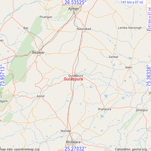
Gulābpura GPS coordinates[2]
25° 54' 16.128" North, 74° 39' 36.9" East
| Map corner | latitude | longitude |
|---|---|---|
| Upper-left | 26.53525°, | 73.95713° |
| Center: | 25.90448°, | 74.66025° |
| Lower-right: | 25.27032°, | 75.36338° |
| Map W x H: | 140.6×140.6 km | = 87.4×87.4mi |
| max Lat: | 34.9274° ⇑30.3% North |
| Gulābpura: | 25.90448° |
| min Lat: | ⇓69.7% South 8.09008° |
| min Long | Gulābpura | max Long |
| 68.82655° | 74.66025° | 96.81° |
| W 14.4%⇐ | ⇒85.6% E |
Elevation
Elevation of Gulābpura is 400 m = 1312 ft, and this is 104.4 m = 343 ft above average elevation for this country.
| Max E: |
3681 m = 12077 ft | 23.9% |
| Gulābpura | 400 m 1312 ft | |
| Avg. | 295.6 m = 970 ft | |
Min E: |
1 m = 3 ft | 76.1% |
See also: India elevation on elevation.city.
Geographical zone
Gulābpura is located in North temperate zone (between Tropic of Cancer and the Arctic Circle). Distance of this Northern Tropic circle is 274.4 km =170.5 mi to South.| Distance of | km | miles | from Gulābpura |
|---|---|---|---|
| North Pole | 7126.8 | 4428.4 | to North |
| Arctic Circle | 4520.9 | 2809.2 | to North |
| Tropic Cancer | 274.4 | 170.5 | to South |
| Equator | 2880.3 | 1789.7 | to South |


Nearby cities:
15 places around Gulābpura: (largest is in red/bold)
• Ajmer
60.9 km =37.8 mi,  357°
357°
• Beāwar
40.4 km =25.1 mi,  302°
302°
• Bhīlwāra
62 km =38.5 mi,  181°
181°
• Deoli
73.9 km =45.9 mi,  102°
102°
• Jahāzpur
69.3 km =43.1 mi,  117°
117°
• Kekri
49.5 km =30.8 mi,  81°
81°
• Māndal
52.3 km =32.5 mi,  189°
189°
• Nasīrābād
45.1 km =28 mi,  9°
9°
• Nīmāj
71.3 km =44.3 mi,  292°
292°
• Pushkar
66 km =41 mi,  350°
350°
• Raipur
65.5 km =40.7 mi,  283°
283°
• Sarwār
39.2 km =24.4 mi,  63°
63°
• Shāhpura
41.2 km =25.6 mi,  139°
139°
• Uniāra
62 km =38.5 mi, 63°
• Āsind
37.9 km =23.5 mi,  239°
239°
Sources, notices
• [Note1] Compared only with cities in India existing in our database
• [Src1] Map data: © OpenStreetMap contributors (CC-BY-SA)
• [Src2] Other city data from geonames.org with taken over terms of usage.
• [Src3] Geographical zone / Annual Mean Temperature by Robert A. Rohde @ Wikipedia
