Kishangarh geodata
Kishangarh (Rajasthan) is a populated place; located in India in Asia/Kolkata (GMT+5.5) time zone. With population of 131,749 people, there are 331 cities with bigger population in this country. Compared to other cities in India, 75.3% of cities are located further ↓South; 84% of cities are located further →East and 78.8% of cities have lower elevation than Kishangarh. Note1


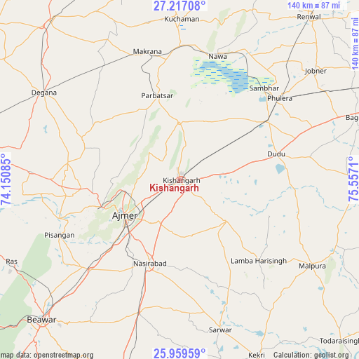
Kishangarh GPS coordinates[2]
26° 35' 24.216" North, 74° 51' 14.292" East
| Map corner | latitude | longitude |
|---|---|---|
| Upper-left | 27.21708°, | 74.15085° |
| Center: | 26.59006°, | 74.85397° |
| Lower-right: | 25.95959°, | 75.5571° |
| Map W x H: | 139.8×139.8 km | = 86.9×86.9mi |
| max Lat: | 34.9274° ⇑24.7% North |
| Kishangarh: | 26.59006° |
| min Lat: | ⇓75.3% South 8.09008° |
| min Long | Kishangarh | max Long |
| 68.82655° | 74.85397° | 96.81° |
| W 16%⇐ | ⇒84% E |
Elevation
Elevation of Kishangarh is 443 m = 1453 ft, and this is 147.4 m = 484 ft above average elevation for this country.
| Max E: |
3681 m = 12077 ft | 21.2% |
| Kishangarh | 443 m 1453 ft | |
| Avg. | 295.6 m = 970 ft | |
Min E: |
1 m = 3 ft | 78.8% |
See also: Kishangarh elevation on elevation.city.
Geographical zone
Kishangarh is located in North temperate zone (between Tropic of Cancer and the Arctic Circle). Distance of this Northern Tropic circle is 350.6 km =217.9 mi to South.| Distance of | km | miles | from Kishangarh |
|---|---|---|---|
| North Pole | 7050.5 | 4381 | to North |
| Arctic Circle | 4444.6 | 2761.7 | to North |
| Tropic Cancer | 350.6 | 217.9 | to South |
| Equator | 2956.5 | 1837.1 | to South |


Nearby cities:
15 places around Kishangarh: (largest is in red/bold)
• Ajmer
26.3 km =16.3 mi,  234°
234°
• Jobner
67.9 km =42.2 mi,  51°
51°
• Kekri
74.9 km =46.5 mi,  156°
156°
• Kuchāman
62 km =38.5 mi,  0°
0°
• Makrāna
52 km =32.3 mi,  345°
345°
• Mālpura
61.2 km =38 mi,  123°
123°
• Naraina
41.5 km =25.8 mi,  57°
57°
• Nasīrābād
33.9 km =21.1 mi,  200°
200°
• Nāwa
50 km =31.1 mi,  17°
17°
• Parvatsar
34 km =21.1 mi, 345°
• Phulera
49.8 km =30.9 mi, 50°
• Pushkar
32 km =19.9 mi,  249°
249°
• Sarwār
60.7 km =37.7 mi,  165°
165°
• Sāmbhar
48.7 km =30.3 mi,  43°
43°
• Uniāra
60.4 km =37.5 mi,  143°
143°
Sources, notices
• [Note1] Compared only with cities in India existing in our database
• [Src1] Map data: © OpenStreetMap contributors (CC-BY-SA)
• [Src2] Other city data from geonames.org with taken over terms of usage.
• [Src3] Geographical zone / Annual Mean Temperature by Robert A. Rohde @ Wikipedia
