Raipur geodata
Raipur (Rajasthan) is a populated place; located in India in Asia/Kolkata (GMT+5.5) time zone. With population of 17,537 people, there are 2231 cities with bigger population in this country. Compared to other cities in India, 70.7% of cities are located further ↓South; 89.2% of cities are located further →East and 70.9% of cities have lower elevation than Raipur. Note1


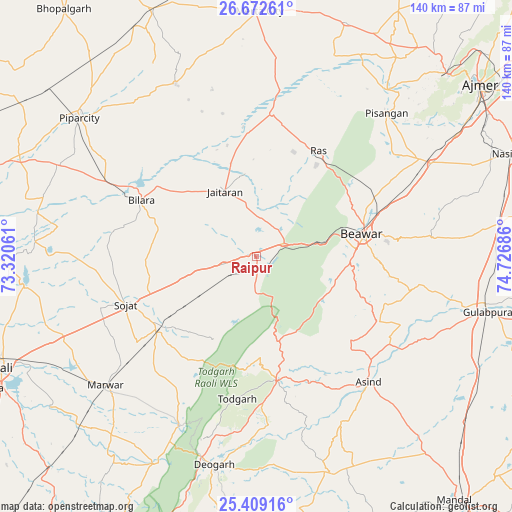
Raipur GPS coordinates[2]
26° 2' 33.324" North, 74° 1' 25.428" East
| Map corner | latitude | longitude |
|---|---|---|
| Upper-left | 26.67261°, | 73.32061° |
| Center: | 26.04259°, | 74.02373° |
| Lower-right: | 25.40916°, | 74.72686° |
| Map W x H: | 140.5×140.5 km | = 87.3×87.3mi |
| max Lat: | 34.9274° ⇑29.3% North |
| Raipur: | 26.04259° |
| min Lat: | ⇓70.7% South 8.09008° |
| min Long | Raipur | max Long |
| 68.82655° | 74.02373° | 96.81° |
| W 10.8%⇐ | ⇒89.2% E |
Elevation
Elevation of Raipur is 336 m = 1102 ft, and this is 40.4 m = 133 ft above average elevation for this country.
| Max E: |
3681 m = 12077 ft | 29.1% |
| Raipur | 336 m 1102 ft | |
| Avg. | 295.6 m = 970 ft | |
Min E: |
1 m = 3 ft | 70.9% |
See also: India elevation on elevation.city.
Geographical zone
Raipur is located in North temperate zone (between Tropic of Cancer and the Arctic Circle). Distance of this Northern Tropic circle is 289.7 km =180 mi to South.| Distance of | km | miles | from Raipur |
|---|---|---|---|
| North Pole | 7111.4 | 4418.8 | to North |
| Arctic Circle | 4505.5 | 2799.6 | to North |
| Tropic Cancer | 289.7 | 180 | to South |
| Equator | 2895.7 | 1799.3 | to South |


Nearby cities:
15 places around Raipur: (largest is in red/bold)
• Ajmer
76.4 km =47.5 mi,  53°
53°
• Amet
82.5 km =51.3 mi,  186°
186°
• Beāwar
30.3 km =18.8 mi,  77°
77°
• Bilāra
35.3 km =21.9 mi,  295°
295°
• Devgarh
58.7 km =36.5 mi, 191°
• Gulābpura
65.5 km =40.7 mi,  103°
103°
• Jaitāran
20 km =12.4 mi,  334°
334°
• Merta
67.4 km =41.9 mi,  0°
0°
• Nasīrābād
76.6 km =47.6 mi,  67°
67°
• Nīmāj
12.2 km =7.6 mi,  349°
349°
• Pushkar
72.5 km =45 mi, 46°
• Pāli
76.2 km =47.3 mi,  246°
246°
• Pīpār
61.1 km =38 mi,  308°
308°
• Sojat
38 km =23.6 mi, 249°
• Āsind
46.2 km =28.7 mi,  137°
137°
Sources, notices
• [Note1] Compared only with cities in India existing in our database
• [Src1] Map data: © OpenStreetMap contributors (CC-BY-SA)
• [Src2] Other city data from geonames.org with taken over terms of usage.
• [Src3] Geographical zone / Annual Mean Temperature by Robert A. Rohde @ Wikipedia
