Jodhpur geodata
Jodhpur (Rajasthan) is a populated place; located in India in Asia/Kolkata (GMT+5.5) time zone. With population of 921,476 people, there are 46 cities with bigger population in this country. Compared to other cities in India, 72.7% of cities are located further ↓South; 94.6% of cities are located further →East and 57.4% of cities have lower elevation than Jodhpur. Note1


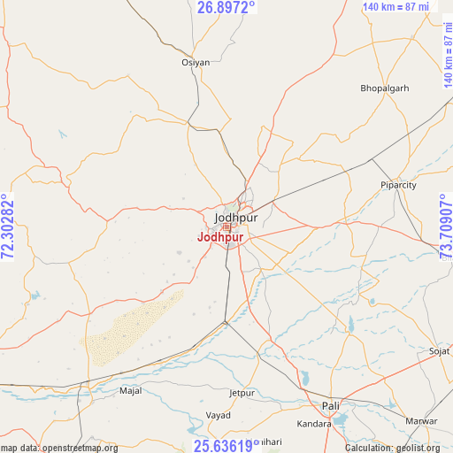
Jodhpur GPS coordinates[2]
26° 16' 6.276" North, 73° 0' 21.384" East
| Map corner | latitude | longitude |
|---|---|---|
| Upper-left | 26.8972°, | 72.30282° |
| Center: | 26.26841°, | 73.00594° |
| Lower-right: | 25.63619°, | 73.70907° |
| Map W x H: | 140.2×140.2 km | = 87.1×87.1mi |
| max Lat: | 34.9274° ⇑27.3% North |
| Jodhpur: | 26.26841° |
| min Lat: | ⇓72.7% South 8.09008° |
| min Long | Jodhpur | max Long |
| 68.82655° | 73.00594° | 96.81° |
| W 5.4%⇐ | ⇒94.6% E |
Elevation
Elevation of Jodhpur is 237 m = 778 ft, and this is 58.6 m = 192 ft below average elevation for this country.
| Max E: |
3681 m = 12077 ft | 42.6% |
| Avg. | 295.6 m = 970 ft | |
| Jodhpur | 237 m = 778 ft | |
Min E: |
1 m = 3 ft | 57.4% |
See also: Jodhpur elevation on elevation.city.
Geographical zone
Jodhpur is located in North temperate zone (between Tropic of Cancer and the Arctic Circle). Distance of this Northern Tropic circle is 314.9 km =195.7 mi to South.| Distance of | km | miles | from Jodhpur |
|---|---|---|---|
| North Pole | 7086.3 | 4403.2 | to North |
| Arctic Circle | 4480.4 | 2784 | to North |
| Tropic Cancer | 314.9 | 195.7 | to South |
| Equator | 2920.8 | 1814.9 | to South |


Nearby cities:
15 places around Jodhpur: (largest is in red/bold)
• Bilāra
70.5 km =43.8 mi,  97°
97°
• Bālotra
90.6 km =56.3 mi,  237°
237°
• Jaitāran
93.1 km =57.8 mi,  94°
94°
• Jalor
109.8 km =68.2 mi,  200°
200°
• Merta
110.7 km =68.8 mi,  67°
67°
• Nīmāj
100.1 km =62.2 mi, 97°
• Phalodi
114.9 km =71.4 mi,  326°
326°
• Pāli
63.6 km =39.5 mi,  150°
150°
• Pīpār
55.1 km =34.2 mi,  76°
76°
• Raipur
104.6 km =65 mi, 103°
• Rāni
106.5 km =66.2 mi,  163°
163°
• Samdari
66.2 km =41.1 mi,  220°
220°
• Siwāna
90 km =55.9 mi, 220°
• Sojat
76.2 km =47.3 mi,  120°
120°
• Takhatgarh
105.2 km =65.4 mi,  180°
180°
Sources, notices
• [Note1] Compared only with cities in India existing in our database
• [Src1] Map data: © OpenStreetMap contributors (CC-BY-SA)
• [Src2] Other city data from geonames.org with taken over terms of usage.
• [Src3] Geographical zone / Annual Mean Temperature by Robert A. Rohde @ Wikipedia
