Sojat geodata
Sojat (Rajasthan) is a populated place; located in India in Asia/Kolkata (GMT+5.5) time zone. With population of 42,556 people, there are 1036 cities with bigger population in this country. Compared to other cities in India, 69.9% of cities are located further ↓South; 91.9% of cities are located further →East and 64.2% of cities have lower elevation than Sojat. Note1


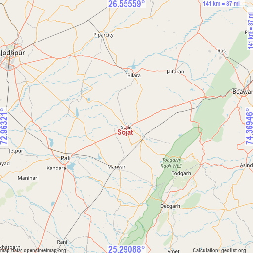
Sojat GPS coordinates[2]
25° 55' 29.748" North, 73° 39' 58.788" East
| Map corner | latitude | longitude |
|---|---|---|
| Upper-left | 26.55559°, | 72.96321° |
| Center: | 25.92493°, | 73.66633° |
| Lower-right: | 25.29088°, | 74.36946° |
| Map W x H: | 140.6×140.6 km | = 87.4×87.4mi |
| max Lat: | 34.9274° ⇑30.1% North |
| Sojat: | 25.92493° |
| min Lat: | ⇓69.9% South 8.09008° |
| min Long | Sojat | max Long |
| 68.82655° | 73.66633° | 96.81° |
| W 8.1%⇐ | ⇒91.9% E |
Elevation
Elevation of Sojat is 280 m = 919 ft, and this is 15.6 m = 51 ft below average elevation for this country.
| Max E: |
3681 m = 12077 ft | 35.8% |
| Avg. | 295.6 m = 970 ft | |
| Sojat | 280 m = 919 ft | |
Min E: |
1 m = 3 ft | 64.2% |
See also: Sojat elevation on elevation.city.
Geographical zone
Sojat is located in North temperate zone (between Tropic of Cancer and the Arctic Circle). Distance of this Northern Tropic circle is 276.7 km =171.9 mi to South.| Distance of | km | miles | from Sojat |
|---|---|---|---|
| North Pole | 7124.5 | 4427 | to North |
| Arctic Circle | 4518.6 | 2807.7 | to North |
| Tropic Cancer | 276.7 | 171.9 | to South |
| Equator | 2882.6 | 1791.2 | to South |


Nearby cities:
15 places around Sojat: (largest is in red/bold)
• Amet
73.6 km =45.7 mi,  159°
159°
• Beāwar
68.2 km =42.4 mi,  73°
73°
• Bilāra
28.7 km =17.8 mi,  7°
7°
• Bāli
89.2 km =55.4 mi,  204°
204°
• Devgarh
50.6 km =31.4 mi,  151°
151°
• Jaitāran
41.2 km =25.6 mi,  40°
40°
• Jodhpur
76.2 km =47.3 mi,  300°
300°
• Merta
88.4 km =54.9 mi,  24°
24°
• Nīmāj
41.8 km =26 mi,  53°
53°
• Pāli
38.3 km =23.8 mi,  243°
243°
• Pīpār
52.5 km =32.6 mi,  346°
346°
• Raipur
38 km =23.6 mi, 69°
• Rāni
73.3 km =45.5 mi,  209°
209°
• Sādri
85 km =52.8 mi,  194°
194°
• Āsind
70 km =43.5 mi,  107°
107°
Sources, notices
• [Note1] Compared only with cities in India existing in our database
• [Src1] Map data: © OpenStreetMap contributors (CC-BY-SA)
• [Src2] Other city data from geonames.org with taken over terms of usage.
• [Src3] Geographical zone / Annual Mean Temperature by Robert A. Rohde @ Wikipedia
