Bilāra geodata
Bilāra (Rajasthan) is a populated place; located in India in Asia/Kolkata (GMT+5.5) time zone. With population of 41,710 people, there are 1059 cities with bigger population in this country. Compared to other cities in India, 71.8% of cities are located further ↓South; 91.8% of cities are located further →East and 63.7% of cities have lower elevation than Bilāra. Note1


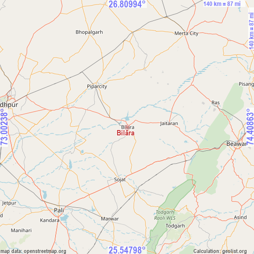
Bilāra GPS coordinates[2]
26° 10' 50.412" North, 73° 42' 19.8" East
| Map corner | latitude | longitude |
|---|---|---|
| Upper-left | 26.80994°, | 73.00238° |
| Center: | 26.18067°, | 73.7055° |
| Lower-right: | 25.54798°, | 74.40863° |
| Map W x H: | 140.3×140.3 km | = 87.2×87.2mi |
| max Lat: | 34.9274° ⇑28.2% North |
| Bilāra: | 26.18067° |
| min Lat: | ⇓71.8% South 8.09008° |
| min Long | Bilāra | max Long |
| 68.82655° | 73.7055° | 96.81° |
| W 8.2%⇐ | ⇒91.8% E |
Elevation
Elevation of Bilāra is 276 m = 906 ft, and this is 19.6 m = 64 ft below average elevation for this country.
| Max E: |
3681 m = 12077 ft | 36.3% |
| Avg. | 295.6 m = 970 ft | |
| Bilāra | 276 m = 906 ft | |
Min E: |
1 m = 3 ft | 63.7% |
See also: Bilāra elevation on elevation.city.
Geographical zone
Bilāra is located in North temperate zone (between Tropic of Cancer and the Arctic Circle). Distance of this Northern Tropic circle is 305.1 km =189.6 mi to South.| Distance of | km | miles | from Bilāra |
|---|---|---|---|
| North Pole | 7096 | 4409.2 | to North |
| Arctic Circle | 4490.2 | 2790.1 | to North |
| Tropic Cancer | 305.1 | 189.6 | to South |
| Equator | 2911 | 1808.8 | to South |


Nearby cities:
15 places around Bilāra: (largest is in red/bold)
• Ajmer
97.8 km =60.8 mi,  72°
72°
• Beāwar
62 km =38.5 mi,  98°
98°
• Devgarh
75.6 km =47 mi,  164°
164°
• Jaitāran
23.2 km =14.4 mi,  83°
83°
• Jodhpur
70.5 km =43.8 mi,  277°
277°
• Kuchera
93.5 km =58.1 mi,  16°
16°
• Merta
61.5 km =38.2 mi,  32°
32°
• Mūndwa
98.8 km =61.4 mi,  6°
6°
• Nīmāj
29.7 km =18.5 mi, 96°
• Pushkar
91.1 km =56.6 mi, 67°
• Pāli
59.3 km =36.8 mi,  220°
220°
• Pīpār
27.8 km =17.3 mi,  324°
324°
• Raipur
35.3 km =21.9 mi,  115°
115°
• Sojat
28.7 km =17.8 mi,  187°
187°
• Āsind
80 km =49.7 mi,  128°
128°
Sources, notices
• [Note1] Compared only with cities in India existing in our database
• [Src1] Map data: © OpenStreetMap contributors (CC-BY-SA)
• [Src2] Other city data from geonames.org with taken over terms of usage.
• [Src3] Geographical zone / Annual Mean Temperature by Robert A. Rohde @ Wikipedia
