Devgarh geodata
Devgarh (Rajasthan) is a populated place; located in India in Asia/Kolkata (GMT+5.5) time zone. With population of 17,500 people, there are 2238 cities with bigger population in this country. Compared to other cities in India, 67% of cities are located further ↓South; 90.2% of cities are located further →East and 90% of cities have lower elevation than Devgarh. Note1


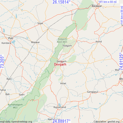
Devgarh GPS coordinates[2]
25° 31' 31.188" North, 73° 54' 29.232" East
| Map corner | latitude | longitude |
|---|---|---|
| Upper-left | 26.15814°, | 73.205° |
| Center: | 25.52533°, | 73.90812° |
| Lower-right: | 24.88917°, | 74.61125° |
| Map W x H: | 141.1×141.1 km | = 87.7×87.7mi |
| max Lat: | 34.9274° ⇑33% North |
| Devgarh: | 25.52533° |
| min Lat: | ⇓67% South 8.09008° |
| min Long | Devgarh | max Long |
| 68.82655° | 73.90812° | 96.81° |
| W 9.8%⇐ | ⇒90.2% E |
Elevation
Elevation of Devgarh is 638 m = 2093 ft, and this is 342.4 m = 1123 ft above average elevation for this country.
| Max E: |
3681 m = 12077 ft | 10% |
| Devgarh | 638 m 2093 ft | |
| Avg. | 295.6 m = 970 ft | |
Min E: |
1 m = 3 ft | 90% |
See also: India elevation on elevation.city.
Geographical zone
Devgarh is located in North temperate zone (between Tropic of Cancer and the Arctic Circle). Distance of this Northern Tropic circle is 232.2 km =144.3 mi to South.| Distance of | km | miles | from Devgarh |
|---|---|---|---|
| North Pole | 7168.9 | 4454.5 | to North |
| Arctic Circle | 4563 | 2835.3 | to North |
| Tropic Cancer | 232.2 | 144.3 | to South |
| Equator | 2838.2 | 1763.6 | to South |


Nearby cities:
15 places around Devgarh: (largest is in red/bold)
• Amet
24.4 km =15.2 mi,  175°
175°
• Bāli
71.9 km =44.7 mi,  239°
239°
• Dariba
68 km =42.3 mi,  160°
160°
• Gangāpur
49.1 km =30.5 mi,  133°
133°
• Jaitāran
75.6 km =47 mi,  2°
2°
• Māndal
67.1 km =41.7 mi,  98°
98°
• Nāthdwāra
65.8 km =40.9 mi,  187°
187°
• Nīmāj
70.1 km =43.6 mi,  7°
7°
• Pāli
64.7 km =40.2 mi,  295°
295°
• Raipur
58.7 km =36.5 mi, 11°
• Rājsamand
50.5 km =31.4 mi, 183°
• Rāni
63.2 km =39.3 mi,  252°
252°
• Sojat
50.6 km =31.4 mi,  331°
331°
• Sādri
59.3 km =36.8 mi,  230°
230°
• Āsind
48.5 km =30.1 mi,  61°
61°
Sources, notices
• [Note1] Compared only with cities in India existing in our database
• [Src1] Map data: © OpenStreetMap contributors (CC-BY-SA)
• [Src2] Other city data from geonames.org with taken over terms of usage.
• [Src3] Geographical zone / Annual Mean Temperature by Robert A. Rohde @ Wikipedia
