Ingrāj Bāzār geodata
Ingrāj Bāzār (West Bengal) is a populated place; located in India in Asia/Kolkata (GMT+5.5) time zone. With population of 170,039 people, there are 255 cities with bigger population in this country. Compared to other cities in India, 63.4% of cities are located further ↓South; 91.6% of cities are located further ←West and 84.4% of cities have higher elevation than Ingrāj Bāzār. Note1


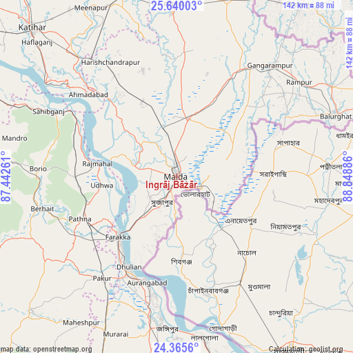
Ingrāj Bāzār GPS coordinates[2]
25° 0' 16.092" North, 88° 8' 44.628" East
| Map corner | latitude | longitude |
|---|---|---|
| Upper-left | 25.64003°, | 87.44261° |
| Center: | 25.00447°, | 88.14573° |
| Lower-right: | 24.3656°, | 88.84886° |
| Map W x H: | 141.7×141.7 km | = 88×88mi |
| max Lat: | 34.9274° ⇑36.6% North |
| Ingrāj Bāzār: | 25.00447° |
| min Lat: | ⇓63.4% South 8.09008° |
| min Long | Ingrāj Bāzār | max Long |
| 68.82655° | 88.14573° | 96.81° |
| W 91.6%⇐ | ⇒8.4% E |
Elevation
Elevation of Ingrāj Bāzār is 32 m = 105 ft, and this is 263.6 m = 865 ft below average elevation for this country.
| Max E: |
3681 m = 12077 ft | 84.4% |
| Avg. | 295.6 m = 970 ft | |
| Ingrāj Bāzār | 32 m = 105 ft | |
Min E: |
1 m = 3 ft | 15.6% |
See also: Ingrāj Bāzār elevation on elevation.city.
Geographical zone
Ingrāj Bāzār is located in North temperate zone (between Tropic of Cancer and the Arctic Circle). Distance of this Northern Tropic circle is 174.3 km =108.3 mi to South.| Distance of | km | miles | from Ingrāj Bāzār |
|---|---|---|---|
| North Pole | 7226.8 | 4490.5 | to North |
| Arctic Circle | 4620.9 | 2871.3 | to North |
| Tropic Cancer | 174.3 | 108.3 | to South |
| Equator | 2780.2 | 1727.5 | to South |


Nearby cities:
15 places around Ingrāj Bāzār: (largest is in red/bold)
• Bālurghāt
68 km =42.3 mi,  69°
69°
• Daulatpur
40.3 km =25 mi,  27°
27°
• Dhuliān
40.8 km =25.4 mi,  208°
208°
• Farakka
32.4 km =20.1 mi,  229°
229°
• Gangārāmpur
58.7 km =36.5 mi,  41°
41°
• Jangipur
59.8 km =37.2 mi,  186°
186°
• Kāliyāganj
72.4 km =45 mi,  14°
14°
• Lālgola
65.6 km =40.8 mi,  170°
170°
• Manihāri
64.7 km =40.2 mi,  305°
305°
• Paikpara
34.3 km =21.3 mi,  220°
220°
• Pakur
50.9 km =31.6 mi, 217°
• Raghunāthpur
74.8 km =46.5 mi,  342°
342°
• Rāiganj
67.7 km =42.1 mi,  358°
358°
• Rājmahal
32.2 km =20 mi,  279°
279°
• Sāhibganj
57.9 km =36 mi,  297°
297°
Sources, notices
• [Note1] Compared only with cities in India existing in our database
• [Src1] Map data: © OpenStreetMap contributors (CC-BY-SA)
• [Src2] Other city data from geonames.org with taken over terms of usage.
• [Src3] Geographical zone / Annual Mean Temperature by Robert A. Rohde @ Wikipedia
