Godda geodata
Godda (Jharkhand) is a populated place; located in India in Asia/Kolkata (GMT+5.5) time zone. With population of 43,658 people, there are 1013 cities with bigger population in this country. Compared to other cities in India, 62.6% of cities are located further ↓South; 89.6% of cities are located further ←West and 68.1% of cities have higher elevation than Godda. Note1


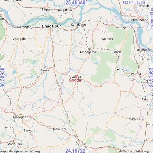
Godda GPS coordinates[2]
24° 49' 37.2" North, 87° 12' 45" East
| Map corner | latitude | longitude |
|---|---|---|
| Upper-left | 25.46349°, | 86.50938° |
| Center: | 24.827°, | 87.2125° |
| Lower-right: | 24.18722°, | 87.91563° |
| Map W x H: | 141.9×141.9 km | = 88.2×88.2mi |
| max Lat: | 34.9274° ⇑37.4% North |
| Godda: | 24.827° |
| min Lat: | ⇓62.6% South 8.09008° |
| min Long | Godda | max Long |
| 68.82655° | 87.2125° | 96.81° |
| W 89.6%⇐ | ⇒10.4% E |
Elevation
Elevation of Godda is 102 m = 335 ft, and this is 193.6 m = 635 ft below average elevation for this country.
| Max E: |
3681 m = 12077 ft | 68.1% |
| Avg. | 295.6 m = 970 ft | |
| Godda | 102 m = 335 ft | |
Min E: |
1 m = 3 ft | 31.9% |
See also: Godda elevation on elevation.city.
Geographical zone
Godda is located in North temperate zone (between Tropic of Cancer and the Arctic Circle). Distance of this Northern Tropic circle is 154.6 km =96.1 mi to South.| Distance of | km | miles | from Godda |
|---|---|---|---|
| North Pole | 7246.6 | 4502.8 | to North |
| Arctic Circle | 4640.7 | 2883.6 | to North |
| Tropic Cancer | 154.6 | 96.1 | to South |
| Equator | 2760.5 | 1715.3 | to South |


Nearby cities:
15 places around Godda: (largest is in red/bold)
• Amarpur
39.2 km =24.4 mi,  307°
307°
• Asarganj
64.1 km =39.8 mi,  304°
304°
• Bhāgalpur
52.4 km =32.6 mi,  332°
332°
• Bānka
29.9 km =18.6 mi,  281°
281°
• Colgong
48.6 km =30.2 mi,  2°
2°
• Dumka
62.3 km =38.7 mi,  176°
176°
• Farakka
69.4 km =43.1 mi,  90°
90°
• Ghoga
43.8 km =27.2 mi,  352°
352°
• Jasidih
67 km =41.6 mi,  238°
238°
• Manihāri
70.2 km =43.6 mi,  35°
35°
• Naugachhia
63.4 km =39.4 mi, 349°
• Paikpara
71.9 km =44.7 mi, 94°
• Pakur
67 km =41.6 mi,  108°
108°
• Rājmahal
67.2 km =41.8 mi,  68°
68°
• Sāhibganj
62.9 km =39.1 mi, 42°
Sources, notices
• [Note1] Compared only with cities in India existing in our database
• [Src1] Map data: © OpenStreetMap contributors (CC-BY-SA)
• [Src2] Other city data from geonames.org with taken over terms of usage.
• [Src3] Geographical zone / Annual Mean Temperature by Robert A. Rohde @ Wikipedia
