Kolāras geodata
Kolāras (Madhya Pradesh) is a populated place; located in India in Asia/Kolkata (GMT+5.5) time zone. With population of 17,174 people, there are 2269 cities with bigger population in this country. Compared to other cities in India, 64.7% of cities are located further ↓South; 55.9% of cities are located further →East and 79.7% of cities have lower elevation than Kolāras. Note1


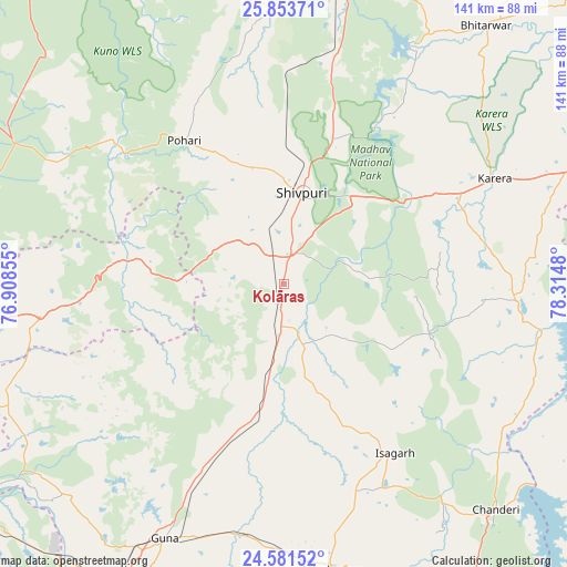
Kolāras GPS coordinates[2]
25° 13' 9.408" North, 77° 36' 42.012" East
| Map corner | latitude | longitude |
|---|---|---|
| Upper-left | 25.85371°, | 76.90855° |
| Center: | 25.21928°, | 77.61167° |
| Lower-right: | 24.58152°, | 78.3148° |
| Map W x H: | 141.5×141.5 km | = 87.9×87.9mi |
| max Lat: | 34.9274° ⇑35.3% North |
| Kolāras: | 25.21928° |
| min Lat: | ⇓64.7% South 8.09008° |
| min Long | Kolāras | max Long |
| 68.82655° | 77.61167° | 96.81° |
| W 44.1%⇐ | ⇒55.9% E |
Elevation
Elevation of Kolāras is 454 m = 1490 ft, and this is 158.4 m = 520 ft above average elevation for this country.
| Max E: |
3681 m = 12077 ft | 20.3% |
| Kolāras | 454 m 1490 ft | |
| Avg. | 295.6 m = 970 ft | |
Min E: |
1 m = 3 ft | 79.7% |
See also: India elevation on elevation.city.
Geographical zone
Kolāras is located in North temperate zone (between Tropic of Cancer and the Arctic Circle). Distance of this Northern Tropic circle is 198.2 km =123.2 mi to South.| Distance of | km | miles | from Kolāras |
|---|---|---|---|
| North Pole | 7202.9 | 4475.7 | to North |
| Arctic Circle | 4597.1 | 2856.5 | to North |
| Tropic Cancer | 198.2 | 123.2 | to South |
| Equator | 2804.1 | 1742.4 | to South |


Nearby cities:
15 places around Kolāras: (largest is in red/bold)
• Ashoknagar
72.6 km =45.1 mi,  170°
170°
• Babīna
86.4 km =53.7 mi,  88°
88°
• Badarwās
27.5 km =17.1 mi,  189°
189°
• Bhitarwār
81 km =50.3 mi,  38°
38°
• Bijrauni
32 km =19.9 mi, 174°
• Bāmor Kalān
65.3 km =40.6 mi,  123°
123°
• Chanderi
77.4 km =48.1 mi,  136°
136°
• Guna
70.5 km =43.8 mi,  205°
205°
• Isāgarh
50.3 km =31.3 mi,  147°
147°
• Karera
59 km =36.7 mi,  63°
63°
• Khailār
93.5 km =58.1 mi,  81°
81°
• Narwar
56.1 km =34.9 mi,  32°
32°
• Shivpuri
23.3 km =14.5 mi,  12°
12°
• Tālbahat
85.1 km =52.9 mi,  103°
103°
• Āron
95.2 km =59.2 mi, 191°
Sources, notices
• [Note1] Compared only with cities in India existing in our database
• [Src1] Map data: © OpenStreetMap contributors (CC-BY-SA)
• [Src2] Other city data from geonames.org with taken over terms of usage.
• [Src3] Geographical zone / Annual Mean Temperature by Robert A. Rohde @ Wikipedia
