Nalgonda geodata
Nalgonda (Telangana) is a populated place; located in India in Asia/Kolkata (GMT+5.5) time zone. With population of 121,826 people, there are 361 cities with bigger population in this country. Compared to other cities in India, 74.6% of cities are located further ↑North; 61.5% of cities are located further ←West and 57.1% of cities have lower elevation than Nalgonda. Note1


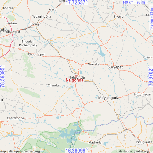
Nalgonda GPS coordinates[2]
17° 3' 15.804" North, 79° 16' 1.452" East
| Map corner | latitude | longitude |
|---|---|---|
| Upper-left | 17.72537°, | 78.56395° |
| Center: | 17.05439°, | 79.26707° |
| Lower-right: | 16.38099°, | 79.9702° |
| Map W x H: | 149.5×149.5 km | = 92.9×92.9mi |
| max Lat: | 34.9274° ⇑74.6% North |
| Nalgonda: | 17.05439° |
| min Lat: | ⇓25.4% South 8.09008° |
| min Long | Nalgonda | max Long |
| 68.82655° | 79.26707° | 96.81° |
| W 61.5%⇐ | ⇒38.5% E |
Elevation
Elevation of Nalgonda is 235 m = 771 ft, and this is 60.6 m = 199 ft below average elevation for this country.
| Max E: |
3681 m = 12077 ft | 42.9% |
| Avg. | 295.6 m = 970 ft | |
| Nalgonda | 235 m = 771 ft | |
Min E: |
1 m = 3 ft | 57.1% |
See also: Nalgonda elevation on elevation.city.
Geographical zone
Nalgonda is located in North Torrid zone (between Equator and Tropic of Cancer). Distance of this Northern Tropic circle is 709.6 km =440.9 mi to North.| Distance of | km | miles | from Nalgonda |
|---|---|---|---|
| North Pole | 8110.8 | 5039.8 | to North |
| Arctic Circle | 5504.9 | 3420.6 | to North |
| Tropic Cancer | 709.6 | 440.9 | to North |
| Equator | 1896.3 | 1178.3 | to South |


Nearby cities:
15 places around Nalgonda: (largest is in red/bold)
• Bhongīr
65.3 km =40.6 mi,  321°
321°
• Bālāpur
86.3 km =53.6 mi,  289°
289°
• Devarkonda
54.6 km =33.9 mi,  222°
222°
• Gaddi Annaram
86.2 km =53.6 mi, 293°
• Ghatkesar
76 km =47.2 mi,  305°
305°
• Gūdūr
67.7 km =42.1 mi, 315°
• Jaggayyapeta
90.2 km =56 mi,  101°
101°
• Jangaon
75.7 km =47 mi,  350°
350°
• Kodār
74.5 km =46.3 mi,  94°
94°
• Lal Bahadur Nagar
82.1 km =51 mi, 293°
• Malkajgiri
90 km =55.9 mi,  299°
299°
• Miriālgūda
37.4 km =23.2 mi,  122°
122°
• Mācherla
66.7 km =41.4 mi,  164°
164°
• Suriāpet
38.8 km =24.1 mi,  75°
75°
• Uppal Kalan
84.7 km =52.6 mi, 297°
Sources, notices
• [Note1] Compared only with cities in India existing in our database
• [Src1] Map data: © OpenStreetMap contributors (CC-BY-SA)
• [Src2] Other city data from geonames.org with taken over terms of usage.
• [Src3] Geographical zone / Annual Mean Temperature by Robert A. Rohde @ Wikipedia
