Suriāpet geodata
Suriāpet (Telangana) is a seat of a second-order administrative division; located in India in Asia/Kolkata (GMT+5.5) time zone. With population of 111,729 people, there are 397 cities with bigger population in this country. Compared to other cities in India, 74.4% of cities are located further ↑North; 64.9% of cities are located further ←West and 54.6% of cities have higher elevation than Suriāpet. Note1


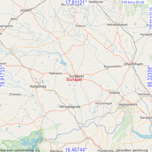
Suriāpet GPS coordinates[2]
17° 8' 25.944" North, 79° 37' 13.62" East
| Map corner | latitude | longitude |
|---|---|---|
| Upper-left | 17.81121°, | 78.91733° |
| Center: | 17.14054°, | 79.62045° |
| Lower-right: | 16.46744°, | 80.32358° |
| Map W x H: | 149.4×149.4 km | = 92.8×92.8mi |
| max Lat: | 34.9274° ⇑74.4% North |
| Suriāpet: | 17.14054° |
| min Lat: | ⇓25.6% South 8.09008° |
| min Long | Suriāpet | max Long |
| 68.82655° | 79.62045° | 96.81° |
| W 64.9%⇐ | ⇒35.1% E |
Elevation
Elevation of Suriāpet is 177 m = 581 ft, and this is 118.6 m = 389 ft below average elevation for this country.
| Max E: |
3681 m = 12077 ft | 54.6% |
| Avg. | 295.6 m = 970 ft | |
| Suriāpet | 177 m = 581 ft | |
Min E: |
1 m = 3 ft | 45.4% |
See also: Suriāpet elevation on elevation.city.
Geographical zone
Suriāpet is located in North Torrid zone (between Equator and Tropic of Cancer). Distance of this Northern Tropic circle is 700.1 km =435 mi to North.| Distance of | km | miles | from Suriāpet |
|---|---|---|---|
| North Pole | 8101.2 | 5033.9 | to North |
| Arctic Circle | 5495.3 | 3414.6 | to North |
| Tropic Cancer | 700.1 | 435 | to North |
| Equator | 1905.8 | 1184.2 | to South |


Nearby cities:
15 places around Suriāpet: (largest is in red/bold)
• Bhongīr
88.4 km =54.9 mi,  298°
298°
• Devarkonda
89.6 km =55.7 mi,  236°
236°
• Dornakal
65.5 km =40.7 mi,  58°
58°
• Gūdūr
93.2 km =57.9 mi,  294°
294°
• Jaggayyapeta
57.7 km =35.9 mi,  118°
118°
• Jangaon
81.9 km =50.9 mi,  322°
322°
• Khammam
56.8 km =35.3 mi,  77°
77°
• Kodār
39.9 km =24.8 mi,  113°
113°
• Mahbūbābād
65 km =40.4 mi,  38°
38°
• Miriālgūda
30.5 km =19 mi,  191°
191°
• Mācherla
76.4 km =47.5 mi, 194°
• Nalgonda
38.8 km =24.1 mi,  255°
255°
• Nandigāma
81.8 km =50.8 mi, 120°
• Warangal
95.6 km =59.4 mi,  357°
357°
• Yellandu
89.7 km =55.7 mi, 56°
Sources, notices
• [Note1] Compared only with cities in India existing in our database
• [Src1] Map data: © OpenStreetMap contributors (CC-BY-SA)
• [Src2] Other city data from geonames.org with taken over terms of usage.
• [Src3] Geographical zone / Annual Mean Temperature by Robert A. Rohde @ Wikipedia
