Miriālgūda geodata
Miriālgūda (Telangana) is a populated place; located in India in Asia/Kolkata (GMT+5.5) time zone. With population of 101,234 people, there are 433 cities with bigger population in this country. Compared to other cities in India, 75.1% of cities are located further ↑North; 64.3% of cities are located further ←West and 62.7% of cities have higher elevation than Miriālgūda. Note1


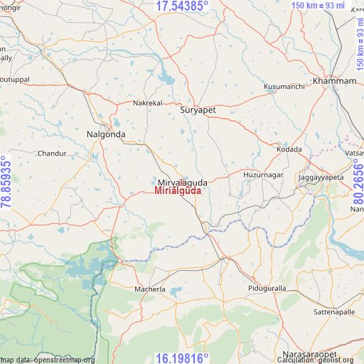
Miriālgūda GPS coordinates[2]
16° 52' 19.92" North, 79° 33' 44.892" East
| Map corner | latitude | longitude |
|---|---|---|
| Upper-left | 17.54385°, | 78.85935° |
| Center: | 16.8722°, | 79.56247° |
| Lower-right: | 16.19816°, | 80.2656° |
| Map W x H: | 149.6×149.6 km | = 93×93mi |
| max Lat: | 34.9274° ⇑75.1% North |
| Miriālgūda: | 16.8722° |
| min Lat: | ⇓24.9% South 8.09008° |
| min Long | Miriālgūda | max Long |
| 68.82655° | 79.56247° | 96.81° |
| W 64.3%⇐ | ⇒35.7% E |
Elevation
Elevation of Miriālgūda is 134 m = 440 ft, and this is 161.6 m = 530 ft below average elevation for this country.
| Max E: |
3681 m = 12077 ft | 62.7% |
| Avg. | 295.6 m = 970 ft | |
| Miriālgūda | 134 m = 440 ft | |
Min E: |
1 m = 3 ft | 37.3% |
See also: Miriālgūda elevation on elevation.city.
Geographical zone
Miriālgūda is located in North Torrid zone (between Equator and Tropic of Cancer). Distance of this Northern Tropic circle is 729.9 km =453.5 mi to North.| Distance of | km | miles | from Miriālgūda |
|---|---|---|---|
| North Pole | 8131 | 5052.4 | to North |
| Arctic Circle | 5525.2 | 3433.2 | to North |
| Tropic Cancer | 729.9 | 453.5 | to North |
| Equator | 1876 | 1165.7 | to South |


Nearby cities:
15 places around Miriālgūda: (largest is in red/bold)
• Devarkonda
71.2 km =44.2 mi,  253°
253°
• Dornakal
89.1 km =55.4 mi,  44°
44°
• Govindapuram,Chilakaluripet,Guntur
98.4 km =61.1 mi,  144°
144°
• Jaggayyapeta
57 km =35.4 mi,  87°
87°
• Khammam
74.6 km =46.4 mi,  55°
55°
• Kodār
45.1 km =28 mi,  71°
71°
• Mahbūbābād
93.2 km =57.9 mi,  30°
30°
• Mācherla
46.1 km =28.6 mi,  197°
197°
• Nalgonda
37.4 km =23.2 mi,  302°
302°
• Nandigāma
77.8 km =48.3 mi,  98°
98°
• Narasaraopet
87.8 km =54.6 mi, 143°
• Phirangipuram
98.7 km =61.3 mi,  130°
130°
• Sattenapalle
82.3 km =51.1 mi, 130°
• Suriāpet
30.5 km =19 mi,  11°
11°
• Vinukonda
93 km =57.8 mi,  168°
168°
Sources, notices
• [Note1] Compared only with cities in India existing in our database
• [Src1] Map data: © OpenStreetMap contributors (CC-BY-SA)
• [Src2] Other city data from geonames.org with taken over terms of usage.
• [Src3] Geographical zone / Annual Mean Temperature by Robert A. Rohde @ Wikipedia
