Devarkonda geodata
Devarkonda (Telangana) is a populated place; located in India in Asia/Kolkata (GMT+5.5) time zone. With population of 29,726 people, there are 1460 cities with bigger population in this country. Compared to other cities in India, 75.8% of cities are located further ↑North; 58.3% of cities are located further ←West and 64.5% of cities have lower elevation than Devarkonda. Note1


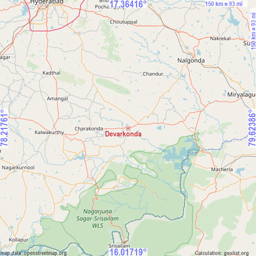
Devarkonda GPS coordinates[2]
16° 41' 30.696" North, 78° 55' 14.628" East
| Map corner | latitude | longitude |
|---|---|---|
| Upper-left | 17.36416°, | 78.21761° |
| Center: | 16.69186°, | 78.92073° |
| Lower-right: | 16.01719°, | 79.62386° |
| Map W x H: | 149.8×149.8 km | = 93.1×93.1mi |
| max Lat: | 34.9274° ⇑75.8% North |
| Devarkonda: | 16.69186° |
| min Lat: | ⇓24.2% South 8.09008° |
| min Long | Devarkonda | max Long |
| 68.82655° | 78.92073° | 96.81° |
| W 58.3%⇐ | ⇒41.7% E |
Elevation
Elevation of Devarkonda is 282 m = 925 ft, and this is 13.6 m = 45 ft below average elevation for this country.
| Max E: |
3681 m = 12077 ft | 35.5% |
| Avg. | 295.6 m = 970 ft | |
| Devarkonda | 282 m = 925 ft | |
Min E: |
1 m = 3 ft | 64.5% |
See also: India elevation on elevation.city.
Geographical zone
Devarkonda is located in North Torrid zone (between Equator and Tropic of Cancer). Distance of this Northern Tropic circle is 750 km =466 mi to North.| Distance of | km | miles | from Devarkonda |
|---|---|---|---|
| North Pole | 8151.1 | 5064.9 | to North |
| Arctic Circle | 5545.2 | 3445.6 | to North |
| Tropic Cancer | 750 | 466 | to North |
| Equator | 1856 | 1153.3 | to South |


Nearby cities:
15 places around Devarkonda: (largest is in red/bold)
• Bhongīr
91.6 km =56.9 mi,  357°
357°
• Bālāpur
82 km =51 mi,  326°
326°
• Farrukhnagar
87.6 km =54.4 mi,  299°
299°
• Gaddi Annaram
86.1 km =53.5 mi, 330°
• Ghatkesar
88.1 km =54.7 mi,  343°
343°
• Gūdūr
89.5 km =55.6 mi,  353°
353°
• Hyderabad
91.4 km =56.8 mi, 327°
• Lal Bahadur Nagar
82.5 km =51.3 mi, 332°
• Miriālgūda
71.2 km =44.2 mi,  73°
73°
• Mācherla
59.8 km =37.2 mi,  113°
113°
• Nalgonda
54.6 km =33.9 mi,  42°
42°
• Nāgar Karnūl
67.7 km =42.1 mi,  249°
249°
• Srīsailain
69.1 km =42.9 mi,  184°
184°
• Suriāpet
89.6 km =55.7 mi,  56°
56°
• Uppal Kalan
88.2 km =54.8 mi, 334°
Sources, notices
• [Note1] Compared only with cities in India existing in our database
• [Src1] Map data: © OpenStreetMap contributors (CC-BY-SA)
• [Src2] Other city data from geonames.org with taken over terms of usage.
• [Src3] Geographical zone / Annual Mean Temperature by Robert A. Rohde @ Wikipedia
