Nainpur geodata
Nainpur (Madhya Pradesh) is a populated place; located in India in Asia/Kolkata (GMT+5.5) time zone. With population of 22,336 people, there are 1883 cities with bigger population in this country. Compared to other cities in India, 53.6% of cities are located further ↑North; 68.6% of cities are located further ←West and 79.3% of cities have lower elevation than Nainpur. Note1


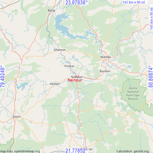
Nainpur GPS coordinates[2]
22° 25' 47.856" North, 80° 6' 20.196" East
| Map corner | latitude | longitude |
|---|---|---|
| Upper-left | 23.07836°, | 79.40249° |
| Center: | 22.42996°, | 80.10561° |
| Lower-right: | 21.77852°, | 80.80874° |
| Map W x H: | 144.5×144.5 km | = 89.8×89.8mi |
| max Lat: | 34.9274° ⇑53.6% North |
| Nainpur: | 22.42996° |
| min Lat: | ⇓46.4% South 8.09008° |
| min Long | Nainpur | max Long |
| 68.82655° | 80.10561° | 96.81° |
| W 68.6%⇐ | ⇒31.4% E |
Elevation
Elevation of Nainpur is 448 m = 1470 ft, and this is 152.4 m = 500 ft above average elevation for this country.
| Max E: |
3681 m = 12077 ft | 20.7% |
| Nainpur | 448 m 1470 ft | |
| Avg. | 295.6 m = 970 ft | |
Min E: |
1 m = 3 ft | 79.3% |
See also: India elevation on elevation.city.
Geographical zone
Nainpur is located in North Torrid zone (between Equator and Tropic of Cancer). Distance of this Northern Tropic circle is 111.9 km =69.5 mi to North.| Distance of | km | miles | from Nainpur |
|---|---|---|---|
| North Pole | 7513.1 | 4668.4 | to North |
| Arctic Circle | 4907.2 | 3049.2 | to North |
| Tropic Cancer | 111.9 | 69.5 | to North |
| Equator | 2494 | 1549.7 | to South |


Nearby cities:
15 places around Nainpur: (largest is in red/bold)
• Baihar
58.5 km =36.4 mi,  128°
128°
• Barela
74.4 km =46.2 mi,  355°
355°
• Barghāt
58.7 km =36.5 mi,  220°
220°
• Bargi
66.7 km =41.4 mi,  339°
339°
• Bālāghāt
68.8 km =42.8 mi,  172°
172°
• Ghansor
30.1 km =18.7 mi,  327°
327°
• Jabalpur
83.5 km =51.9 mi,  348°
348°
• Katangi
79.3 km =49.3 mi,  202°
202°
• Khamaria
91.4 km =56.8 mi, 345°
• Lakhnādon
55.2 km =34.3 mi,  290°
290°
• Mandlā
33.1 km =20.6 mi,  55°
55°
• Seoni
68.8 km =42.8 mi,  236°
236°
• Shāhpura
90.7 km =56.4 mi, 330°
• Ukwā
63.1 km =39.2 mi,  143°
143°
• Wārāseonī
74.6 km =46.4 mi,  184°
184°
Sources, notices
• [Note1] Compared only with cities in India existing in our database
• [Src1] Map data: © OpenStreetMap contributors (CC-BY-SA)
• [Src2] Other city data from geonames.org with taken over terms of usage.
• [Src3] Geographical zone / Annual Mean Temperature by Robert A. Rohde @ Wikipedia
