Barela geodata
Barela (Madhya Pradesh) is a populated place; located in India in Asia/Kolkata (GMT+5.5) time zone. With population of 11,648 people, there are 2770 cities with bigger population in this country. Compared to other cities in India, 52.3% of cities are located further ↓South; 68.2% of cities are located further ←West and 77.7% of cities have lower elevation than Barela. Note1


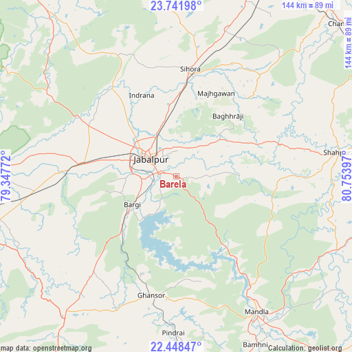
Barela GPS coordinates[2]
23° 5' 48.408" North, 80° 3' 3.024" East
| Map corner | latitude | longitude |
|---|---|---|
| Upper-left | 23.74198°, | 79.34772° |
| Center: | 23.09678°, | 80.05084° |
| Lower-right: | 22.44847°, | 80.75397° |
| Map W x H: | 143.8×143.8 km | = 89.4×89.4mi |
| max Lat: | 34.9274° ⇑47.7% North |
| Barela: | 23.09678° |
| min Lat: | ⇓52.3% South 8.09008° |
| min Long | Barela | max Long |
| 68.82655° | 80.05084° | 96.81° |
| W 68.2%⇐ | ⇒31.8% E |
Elevation
Elevation of Barela is 426 m = 1398 ft, and this is 130.4 m = 428 ft above average elevation for this country.
| Max E: |
3681 m = 12077 ft | 22.3% |
| Barela | 426 m 1398 ft | |
| Avg. | 295.6 m = 970 ft | |
Min E: |
1 m = 3 ft | 77.7% |
See also: India elevation on elevation.city.
Geographical zone
Barela is located in North Torrid zone (between Equator and Tropic of Cancer). Distance of this Northern Tropic circle is 37.8 km =23.5 mi to North.| Distance of | km | miles | from Barela |
|---|---|---|---|
| North Pole | 7438.9 | 4622.3 | to North |
| Arctic Circle | 4833.1 | 3003.1 | to North |
| Tropic Cancer | 37.8 | 23.5 | to North |
| Equator | 2568.1 | 1595.7 | to South |


Nearby cities:
15 places around Barela: (largest is in red/bold)
• Bargi
21.4 km =13.3 mi,  236°
236°
• Ghansor
49.7 km =30.9 mi,  191°
191°
• Jabalpur
12.9 km =8 mi,  307°
307°
• Kaimori
44.8 km =27.8 mi,  315°
315°
• Katangi
46.3 km =28.8 mi,  325°
325°
• Khamaria
22.6 km =14 mi, 309°
• Lakhnādon
71.9 km =44.7 mi,  219°
219°
• Majholi
46.8 km =29.1 mi,  343°
343°
• Mandlā
64.4 km =40 mi,  149°
149°
• Nainpur
74.4 km =46.2 mi,  175°
175°
• Panāgar
21.7 km =13.5 mi, 344°
• Pātan
42.5 km =26.4 mi,  299°
299°
• Shāhpura
39.8 km =24.7 mi,  276°
276°
• Sihorā
43.7 km =27.2 mi,  7°
7°
• Tendūkheda
61.9 km =38.5 mi, 302°
Sources, notices
• [Note1] Compared only with cities in India existing in our database
• [Src1] Map data: © OpenStreetMap contributors (CC-BY-SA)
• [Src2] Other city data from geonames.org with taken over terms of usage.
• [Src3] Geographical zone / Annual Mean Temperature by Robert A. Rohde @ Wikipedia
