Bargi geodata
Bargi (Madhya Pradesh) is a populated place; located in India in Asia/Kolkata (GMT+5.5) time zone. With population of 17,588 people, there are 2227 cities with bigger population in this country. Compared to other cities in India, 51.5% of cities are located further ↓South; 66.9% of cities are located further ←West and 76.2% of cities have lower elevation than Bargi. Note1


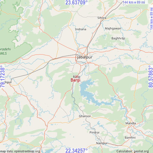
Bargi GPS coordinates[2]
22° 59' 28.968" North, 79° 52' 31.8" East
| Map corner | latitude | longitude |
|---|---|---|
| Upper-left | 23.63709°, | 79.17238° |
| Center: | 22.99138°, | 79.8755° |
| Lower-right: | 22.34257°, | 80.57863° |
| Map W x H: | 143.9×143.9 km | = 89.4×89.4mi |
| max Lat: | 34.9274° ⇑48.5% North |
| Bargi: | 22.99138° |
| min Lat: | ⇓51.5% South 8.09008° |
| min Long | Bargi | max Long |
| 68.82655° | 79.8755° | 96.81° |
| W 66.9%⇐ | ⇒33.1% E |
Elevation
Elevation of Bargi is 401 m = 1316 ft, and this is 105.4 m = 346 ft above average elevation for this country.
| Max E: |
3681 m = 12077 ft | 23.8% |
| Bargi | 401 m 1316 ft | |
| Avg. | 295.6 m = 970 ft | |
Min E: |
1 m = 3 ft | 76.2% |
See also: India elevation on elevation.city.
Geographical zone
Bargi is located in North Torrid zone (between Equator and Tropic of Cancer). Distance of this Northern Tropic circle is 49.5 km =30.8 mi to North.| Distance of | km | miles | from Bargi |
|---|---|---|---|
| North Pole | 7450.7 | 4629.6 | to North |
| Arctic Circle | 4844.8 | 3010.4 | to North |
| Tropic Cancer | 49.5 | 30.8 | to North |
| Equator | 2556.4 | 1588.5 | to South |


Nearby cities:
15 places around Bargi: (largest is in red/bold)
• Barela
21.4 km =13.3 mi,  56°
56°
• Ghansor
37.7 km =23.4 mi,  168°
168°
• Jabalpur
21 km =13 mi,  21°
21°
• Kaimori
45.7 km =28.4 mi,  342°
342°
• Katangi
50.7 km =31.5 mi,  350°
350°
• Khamaria
26 km =16.2 mi,  1°
1°
• Lakhnādon
51.8 km =32.2 mi,  212°
212°
• Majholi
56.9 km =35.4 mi, 4°
• Mandlā
67 km =41.6 mi,  130°
130°
• Nainpur
66.7 km =41.4 mi,  159°
159°
• Panāgar
34.9 km =21.7 mi, 20°
• Pātan
37.9 km =23.5 mi,  329°
329°
• Shāhpura
27 km =16.8 mi,  306°
306°
• Sihorā
59.9 km =37.2 mi, 22°
• Tendūkheda
56.6 km =35.2 mi,  322°
322°
Sources, notices
• [Note1] Compared only with cities in India existing in our database
• [Src1] Map data: © OpenStreetMap contributors (CC-BY-SA)
• [Src2] Other city data from geonames.org with taken over terms of usage.
• [Src3] Geographical zone / Annual Mean Temperature by Robert A. Rohde @ Wikipedia
