Seoni geodata
Seoni (Madhya Pradesh) is a populated place; located in India in Asia/Kolkata (GMT+5.5) time zone. With population of 101,379 people, there are 431 cities with bigger population in this country. Compared to other cities in India, 56.2% of cities are located further ↑North; 64.2% of cities are located further ←West and 89.6% of cities have lower elevation than Seoni. Note1


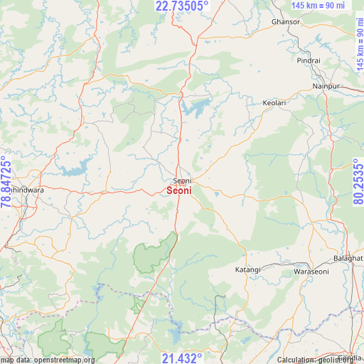
Seoni GPS coordinates[2]
22° 5' 6.108" North, 79° 33' 1.332" East
| Map corner | latitude | longitude |
|---|---|---|
| Upper-left | 22.73505°, | 78.84725° |
| Center: | 22.08503°, | 79.55037° |
| Lower-right: | 21.432°, | 80.2535° |
| Map W x H: | 144.9×144.9 km | = 90×90mi |
| max Lat: | 34.9274° ⇑56.2% North |
| Seoni: | 22.08503° |
| min Lat: | ⇓43.8% South 8.09008° |
| min Long | Seoni | max Long |
| 68.82655° | 79.55037° | 96.81° |
| W 64.2%⇐ | ⇒35.8% E |
Elevation
Elevation of Seoni is 628 m = 2060 ft, and this is 332.4 m = 1091 ft above average elevation for this country.
| Max E: |
3681 m = 12077 ft | 10.4% |
| Seoni | 628 m 2060 ft | |
| Avg. | 295.6 m = 970 ft | |
Min E: |
1 m = 3 ft | 89.6% |
See also: Seoni elevation on elevation.city.
Geographical zone
Seoni is located in North Torrid zone (between Equator and Tropic of Cancer). Distance of this Northern Tropic circle is 150.3 km =93.4 mi to North.| Distance of | km | miles | from Seoni |
|---|---|---|---|
| North Pole | 7551.4 | 4692.2 | to North |
| Arctic Circle | 4945.5 | 3073 | to North |
| Tropic Cancer | 150.3 | 93.4 | to North |
| Equator | 2455.6 | 1525.8 | to South |


Nearby cities:
15 places around Seoni: (largest is in red/bold)
• Amarwāra
45.8 km =28.5 mi,  301°
301°
• Barghāt
19.7 km =12.2 mi,  107°
107°
• Bālāghāt
72.3 km =44.9 mi, 114°
• Chhindwāra
63 km =39.1 mi,  267°
267°
• Chicholi
70.2 km =43.6 mi,  167°
167°
• Ghansor
76 km =47.2 mi,  32°
32°
• Harrai
67.8 km =42.1 mi,  330°
330°
• Hīrāpur Hamesha
63.7 km =39.6 mi,  157°
157°
• Katangi
43.5 km =27 mi,  142°
142°
• Kāndri
79.1 km =49.2 mi,  200°
200°
• Lakhnādon
57.5 km =35.7 mi,  5°
5°
• Nainpur
68.8 km =42.8 mi,  56°
56°
• Rāmtek
80 km =49.7 mi, 196°
• Tirodi
47.7 km =29.6 mi, 158°
• Wārāseonī
62.2 km =38.6 mi,  125°
125°
Sources, notices
• [Note1] Compared only with cities in India existing in our database
• [Src1] Map data: © OpenStreetMap contributors (CC-BY-SA)
• [Src2] Other city data from geonames.org with taken over terms of usage.
• [Src3] Geographical zone / Annual Mean Temperature by Robert A. Rohde @ Wikipedia
