Jabalpur geodata
Jabalpur (Madhya Pradesh) is a populated place; located in India in Asia/Kolkata (GMT+5.5) time zone. With population of 1,030,168 people, there are 38 cities with bigger population in this country. Compared to other cities in India, 52.6% of cities are located further ↓South; 67.4% of cities are located further ←West and 77.1% of cities have lower elevation than Jabalpur. Note1


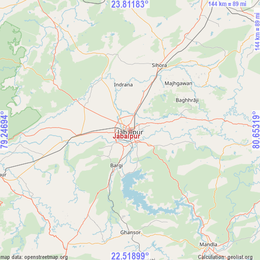
Jabalpur GPS coordinates[2]
23° 10' 1.092" North, 79° 57' 0.216" East
| Map corner | latitude | longitude |
|---|---|---|
| Upper-left | 23.81183°, | 79.24694° |
| Center: | 23.16697°, | 79.95006° |
| Lower-right: | 22.51899°, | 80.65319° |
| Map W x H: | 143.8×143.8 km | = 89.4×89.4mi |
| max Lat: | 34.9274° ⇑47.4% North |
| Jabalpur: | 23.16697° |
| min Lat: | ⇓52.6% South 8.09008° |
| min Long | Jabalpur | max Long |
| 68.82655° | 79.95006° | 96.81° |
| W 67.4%⇐ | ⇒32.6% E |
Elevation
Elevation of Jabalpur is 416 m = 1365 ft, and this is 120.4 m = 395 ft above average elevation for this country.
| Max E: |
3681 m = 12077 ft | 22.9% |
| Jabalpur | 416 m 1365 ft | |
| Avg. | 295.6 m = 970 ft | |
Min E: |
1 m = 3 ft | 77.1% |
See also: Jabalpur elevation on elevation.city.
Geographical zone
Jabalpur is located in North Torrid zone (between Equator and Tropic of Cancer). Distance of this Northern Tropic circle is 30 km =18.6 mi to North.| Distance of | km | miles | from Jabalpur |
|---|---|---|---|
| North Pole | 7431.1 | 4617.5 | to North |
| Arctic Circle | 4825.2 | 2998.2 | to North |
| Tropic Cancer | 30 | 18.6 | to North |
| Equator | 2575.9 | 1600.6 | to South |


Nearby cities:
15 places around Jabalpur: (largest is in red/bold)
• Barela
12.9 km =8 mi,  127°
127°
• Bargi
21 km =13 mi,  201°
201°
• Ghansor
56.4 km =35 mi,  179°
179°
• Kaimori
32.1 km =19.9 mi,  319°
319°
• Katangi
34.3 km =21.3 mi,  332°
332°
• Khamaria
9.7 km =6 mi,  312°
312°
• Lakhnādon
72.4 km =45 mi,  209°
209°
• Majholi
37.3 km =23.2 mi,  355°
355°
• Mandlā
76.5 km =47.5 mi,  145°
145°
• Narsimhapur
82.1 km =51 mi,  252°
252°
• Panāgar
13.9 km =8.6 mi,  19°
19°
• Pātan
29.7 km =18.5 mi,  296°
296°
• Shāhpura
29.4 km =18.3 mi,  263°
263°
• Sihorā
38.9 km =24.2 mi, 23°
• Tendūkheda
49.1 km =30.5 mi, 301°
Sources, notices
• [Note1] Compared only with cities in India existing in our database
• [Src1] Map data: © OpenStreetMap contributors (CC-BY-SA)
• [Src2] Other city data from geonames.org with taken over terms of usage.
• [Src3] Geographical zone / Annual Mean Temperature by Robert A. Rohde @ Wikipedia
