Baihar geodata
Baihar (Madhya Pradesh) is a populated place; located in India in Asia/Kolkata (GMT+5.5) time zone. With population of 16,168 people, there are 2360 cities with bigger population in this country. Compared to other cities in India, 56.1% of cities are located further ↑North; 71.2% of cities are located further ←West and 85.5% of cities have lower elevation than Baihar. Note1


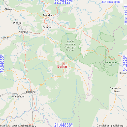
Baihar GPS coordinates[2]
22° 6' 4.788" North, 80° 32' 58.812" East
| Map corner | latitude | longitude |
|---|---|---|
| Upper-left | 22.75127°, | 79.84655° |
| Center: | 22.10133°, | 80.54967° |
| Lower-right: | 21.44838°, | 81.2528° |
| Map W x H: | 144.9×144.9 km | = 90×90mi |
| max Lat: | 34.9274° ⇑56.1% North |
| Baihar: | 22.10133° |
| min Lat: | ⇓43.9% South 8.09008° |
| min Long | Baihar | max Long |
| 68.82655° | 80.54967° | 96.81° |
| W 71.2%⇐ | ⇒28.8% E |
Elevation
Elevation of Baihar is 556 m = 1824 ft, and this is 260.4 m = 854 ft above average elevation for this country.
| Max E: |
3681 m = 12077 ft | 14.5% |
| Baihar | 556 m 1824 ft | |
| Avg. | 295.6 m = 970 ft | |
Min E: |
1 m = 3 ft | 85.5% |
See also: India elevation on elevation.city.
Geographical zone
Baihar is located in North Torrid zone (between Equator and Tropic of Cancer). Distance of this Northern Tropic circle is 148.5 km =92.3 mi to North.| Distance of | km | miles | from Baihar |
|---|---|---|---|
| North Pole | 7549.6 | 4691.1 | to North |
| Arctic Circle | 4943.7 | 3071.9 | to North |
| Tropic Cancer | 148.5 | 92.3 | to North |
| Equator | 2457.4 | 1527 | to South |


Nearby cities:
15 places around Baihar: (largest is in red/bold)
• Barghāt
84.5 km =52.5 mi,  264°
264°
• Bālāghāt
49 km =30.4 mi,  229°
229°
• Chhuīkhadān
79.2 km =49.2 mi,  144°
144°
• Gandai
74.6 km =46.4 mi,  130°
130°
• Ghansor
87.5 km =54.4 mi,  315°
315°
• Gondiā
80.3 km =49.9 mi,  207°
207°
• Katangi
85 km =52.8 mi,  244°
244°
• Kawardha
71 km =44.1 mi,  98°
98°
• Khairāgarh
87.9 km =54.6 mi,  149°
149°
• Mandlā
58.3 km =36.2 mi,  341°
341°
• Nainpur
58.5 km =36.4 mi,  308°
308°
• Pandaria
89.6 km =55.7 mi,  81°
81°
• Pāndātarai
80.7 km =50.1 mi, 83°
• Ukwā
16.8 km =10.4 mi, 210°
• Wārāseonī
64.5 km =40.1 mi, 234°
Sources, notices
• [Note1] Compared only with cities in India existing in our database
• [Src1] Map data: © OpenStreetMap contributors (CC-BY-SA)
• [Src2] Other city data from geonames.org with taken over terms of usage.
• [Src3] Geographical zone / Annual Mean Temperature by Robert A. Rohde @ Wikipedia
