Bālāghāt geodata
Bālāghāt (Madhya Pradesh) is a populated place; located in India in Asia/Kolkata (GMT+5.5) time zone. With population of 80,360 people, there are 545 cities with bigger population in this country. Compared to other cities in India, 57.4% of cities are located further ↑North; 69.5% of cities are located further ←West and 69.2% of cities have lower elevation than Bālāghāt. Note1


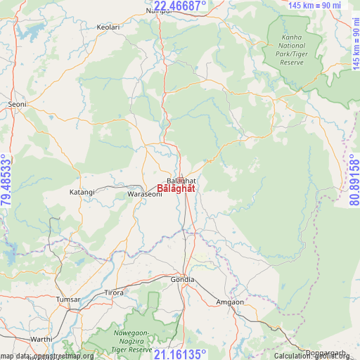
Bālāghāt GPS coordinates[2]
21° 48' 56.16" North, 80° 11' 18.42" East
| Map corner | latitude | longitude |
|---|---|---|
| Upper-left | 22.46687°, | 79.48533° |
| Center: | 21.8156°, | 80.18845° |
| Lower-right: | 21.16135°, | 80.89158° |
| Map W x H: | 145.2×145.2 km | = 90.2×90.2mi |
| max Lat: | 34.9274° ⇑57.4% North |
| Bālāghāt: | 21.8156° |
| min Lat: | ⇓42.6% South 8.09008° |
| min Long | Bālāghāt | max Long |
| 68.82655° | 80.18845° | 96.81° |
| W 69.5%⇐ | ⇒30.5% E |
Elevation
Elevation of Bālāghāt is 319 m = 1047 ft, and this is 23.4 m = 77 ft above average elevation for this country.
| Max E: |
3681 m = 12077 ft | 30.8% |
| Bālāghāt | 319 m 1047 ft | |
| Avg. | 295.6 m = 970 ft | |
Min E: |
1 m = 3 ft | 69.2% |
See also: Bālāghāt elevation on elevation.city.
Geographical zone
Bālāghāt is located in North Torrid zone (between Equator and Tropic of Cancer). Distance of this Northern Tropic circle is 180.3 km =112 mi to North.| Distance of | km | miles | from Bālāghāt |
|---|---|---|---|
| North Pole | 7581.4 | 4710.9 | to North |
| Arctic Circle | 4975.5 | 3091.6 | to North |
| Tropic Cancer | 180.3 | 112 | to North |
| Equator | 2425.7 | 1507.3 | to South |


Nearby cities:
15 places around Bālāghāt: (largest is in red/bold)
• Baihar
49 km =30.4 mi,  49°
49°
• Barghāt
52.7 km =32.7 mi,  296°
296°
• Chhuīkhadān
89.7 km =55.7 mi,  111°
111°
• Chicholi
63.4 km =39.4 mi,  232°
232°
• Dongargarh
91 km =56.5 mi,  139°
139°
• Gondiā
39.5 km =24.5 mi,  179°
179°
• Hīrāpur Hamesha
50.7 km =31.5 mi,  235°
235°
• Katangi
39.8 km =24.7 mi,  263°
263°
• Mandlā
89.1 km =55.4 mi,  12°
12°
• Nainpur
68.8 km =42.8 mi,  352°
352°
• Seoni
72.3 km =44.9 mi,  294°
294°
• Tirodi
50.6 km =31.4 mi,  253°
253°
• Tumsar
67.3 km =41.8 mi,  224°
224°
• Ukwā
33.5 km =20.8 mi,  58°
58°
• Wārāseonī
16.2 km =10.1 mi, 248°
Sources, notices
• [Note1] Compared only with cities in India existing in our database
• [Src1] Map data: © OpenStreetMap contributors (CC-BY-SA)
• [Src2] Other city data from geonames.org with taken over terms of usage.
• [Src3] Geographical zone / Annual Mean Temperature by Robert A. Rohde @ Wikipedia
