Ghansor geodata
Ghansor (Madhya Pradesh) is a populated place; located in India in Asia/Kolkata (GMT+5.5) time zone. With population of 6,597 people, there are 3242 cities with bigger population in this country. Compared to other cities in India, 51.5% of cities are located further ↑North; 67.4% of cities are located further ←West and 86.3% of cities have lower elevation than Ghansor. Note1


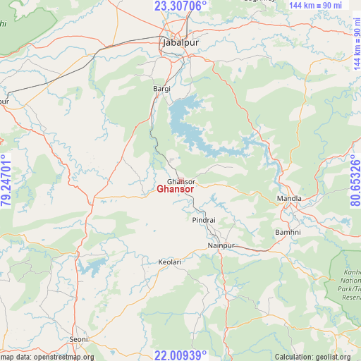
Ghansor GPS coordinates[2]
22° 39' 35.136" North, 79° 57' 0.468" East
| Map corner | latitude | longitude |
|---|---|---|
| Upper-left | 23.30706°, | 79.24701° |
| Center: | 22.65976°, | 79.95013° |
| Lower-right: | 22.00939°, | 80.65326° |
| Map W x H: | 144.3×144.3 km | = 89.7×89.7mi |
| max Lat: | 34.9274° ⇑51.5% North |
| Ghansor: | 22.65976° |
| min Lat: | ⇓48.5% South 8.09008° |
| min Long | Ghansor | max Long |
| 68.82655° | 79.95013° | 96.81° |
| W 67.4%⇐ | ⇒32.6% E |
Elevation
Elevation of Ghansor is 566 m = 1857 ft, and this is 270.4 m = 887 ft above average elevation for this country.
| Max E: |
3681 m = 12077 ft | 13.7% |
| Ghansor | 566 m 1857 ft | |
| Avg. | 295.6 m = 970 ft | |
Min E: |
1 m = 3 ft | 86.3% |
See also: India elevation on elevation.city.
Geographical zone
Ghansor is located in North Torrid zone (between Equator and Tropic of Cancer). Distance of this Northern Tropic circle is 86.4 km =53.7 mi to North.| Distance of | km | miles | from Ghansor |
|---|---|---|---|
| North Pole | 7487.5 | 4652.5 | to North |
| Arctic Circle | 4881.6 | 3033.3 | to North |
| Tropic Cancer | 86.4 | 53.7 | to North |
| Equator | 2519.5 | 1565.5 | to South |


Nearby cities:
15 places around Ghansor: (largest is in red/bold)
• Barela
49.7 km =30.9 mi,  11°
11°
• Barghāt
73.4 km =45.6 mi,  197°
197°
• Bargi
37.7 km =23.4 mi,  348°
348°
• Harrai
74.9 km =46.5 mi,  266°
266°
• Jabalpur
56.4 km =35 mi,  359°
359°
• Kaimori
83.3 km =51.8 mi, 345°
• Khamaria
63.3 km =39.3 mi, 353°
• Lakhnādon
36.4 km =22.6 mi,  259°
259°
• Mandlā
43.7 km =27.2 mi,  98°
98°
• Nainpur
30.1 km =18.7 mi,  147°
147°
• Narsimhapur
84.9 km =52.8 mi,  292°
292°
• Panāgar
69.7 km =43.3 mi,  3°
3°
• Pātan
74.6 km =46.4 mi,  339°
339°
• Seoni
76 km =47.2 mi,  212°
212°
• Shāhpura
60.6 km =37.7 mi,  331°
331°
Sources, notices
• [Note1] Compared only with cities in India existing in our database
• [Src1] Map data: © OpenStreetMap contributors (CC-BY-SA)
• [Src2] Other city data from geonames.org with taken over terms of usage.
• [Src3] Geographical zone / Annual Mean Temperature by Robert A. Rohde @ Wikipedia
