Mandāwar geodata
Mandāwar (Uttar Pradesh) is a populated place; located in India in Asia/Kolkata (GMT+5.5) time zone. With population of 21,339 people, there are 1945 cities with bigger population in this country. Compared to other cities in India, 91.1% of cities are located further ↓South; 50.2% of cities are located further ←West and 58.6% of cities have lower elevation than Mandāwar. Note1


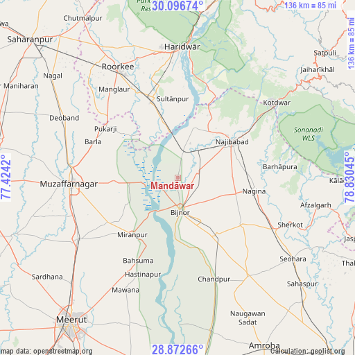
Mandāwar GPS coordinates[2]
29° 29' 11.58" North, 78° 7' 38.352" East
| Map corner | latitude | longitude |
|---|---|---|
| Upper-left | 30.09674°, | 77.4242° |
| Center: | 29.48655°, | 78.12732° |
| Lower-right: | 28.87266°, | 78.83045° |
| Map W x H: | 136.1×136.1 km | = 84.6×84.6mi |
| max Lat: | 34.9274° ⇑8.9% North |
| Mandāwar: | 29.48655° |
| min Lat: | ⇓91.1% South 8.09008° |
| min Long | Mandāwar | max Long |
| 68.82655° | 78.12732° | 96.81° |
| W 50.2%⇐ | ⇒49.8% E |
Elevation
Elevation of Mandāwar is 243 m = 797 ft, and this is 52.6 m = 173 ft below average elevation for this country.
| Max E: |
3681 m = 12077 ft | 41.4% |
| Avg. | 295.6 m = 970 ft | |
| Mandāwar | 243 m = 797 ft | |
Min E: |
1 m = 3 ft | 58.6% |
See also: India elevation on elevation.city.
Geographical zone
Mandāwar is located in North temperate zone (between Tropic of Cancer and the Arctic Circle). Distance of this Northern Tropic circle is 672.7 km =418 mi to South.| Distance of | km | miles | from Mandāwar |
|---|---|---|---|
| North Pole | 6728.5 | 4180.9 | to North |
| Arctic Circle | 4122.6 | 2561.7 | to North |
| Tropic Cancer | 672.7 | 418 | to South |
| Equator | 3278.6 | 2037.2 | to South |


Nearby cities:
15 places around Mandāwar: (largest is in red/bold)
• Bahsūma
35.2 km =21.9 mi,  205°
205°
• Bijnor
12.7 km =7.9 mi,  176°
176°
• Chāndpur
41.5 km =25.8 mi,  160°
160°
• Haldaur
26.6 km =16.5 mi,  145°
145°
• Hastināpur
38.1 km =23.7 mi,  197°
197°
• Jhālu
19.3 km =12 mi, 150°
• Jānsath
32.3 km =20.1 mi,  236°
236°
• Kīratpur
7.9 km =4.9 mi,  73°
73°
• Laksar
31.4 km =19.5 mi,  344°
344°
• Muzaffarnagar
41.1 km =25.5 mi,  267°
267°
• Mīrānpur
27.8 km =17.3 mi,  218°
218°
• Nagīna
30.3 km =18.8 mi,  98°
98°
• Najībābād
25.1 km =15.6 mi,  56°
56°
• Nihtaur
31 km =19.3 mi,  125°
125°
• Sultānpur
29.9 km =18.6 mi,  356°
356°
Sources, notices
• [Note1] Compared only with cities in India existing in our database
• [Src1] Map data: © OpenStreetMap contributors (CC-BY-SA)
• [Src2] Other city data from geonames.org with taken over terms of usage.
• [Src3] Geographical zone / Annual Mean Temperature by Robert A. Rohde @ Wikipedia
